IMAGES TAKEN NEAR TO
Cordingley Way, TELFORD, TF2 7LJ
Introduction
This page details the photographs taken nearby to Cordingley Way, TF2 7LJ by members of the Geograph project.
The Geograph project started in 2005 with the aim of publishing, organising and preserving representative images for every square kilometre of Great Britain, Ireland and the Isle of Man.

There are currently over 7.5m images from over14,400 individuals and you can help contribute to the project by visiting https://www.geograph.org.uk
Image Map
Images are licensed for reuse under creativecommons.org/licenses/by-sa/2.0
Notes
- Clicking on the map will re-center to the selected point.
- The higher the marker number, the further away the image location is from the centre of the postcode.
Image Listing (19 Images Found)
Images are licensed for reuse under creativecommons.org/licenses/by-sa/2.0
Image
Details
Distance
1
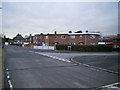
Housing at the junction of West Avenue and Park Road, Donnington
Much of the housing in this part of Telford appears to pre-date the Telford Devt Corporation's work on the town, most of which took place from the late 1960s onwards.
Image: © Richard Law
Taken: 15 Jan 2011
0.10 miles
2
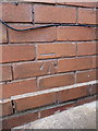
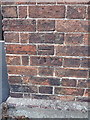
OS benchmark -Wrockwardine Wood, Furnace Lane
An OS cutmark on a house called Fairview; originally levelled at 104.16m above Ordnance Datum Newlyn.
Image: © Richard Law
Taken: 10 Aug 2014
0.15 miles
3
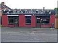
Award-winning Chip Shop
This humble building is home to a chip shop that has enjoyed a high reputation for decades. Years ago it was Percy Dean's and was famous for good quality then, but in 2007, under its new name it won county-wide acclaim.
Image: © Mike White
Taken: 11 Jul 2008
0.15 miles
4
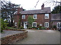
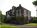
The Rectory, Wrockwardine Wood
Built in the early 19th century, around the same time as the nearby Image, and Grade II listed https://britishlistedbuildings.co.uk/101025281-rectory-holy-trinity-wrockwardine-wood-and-trench#.XBvJINSLTGg in 1983.
Image: © Richard Law
Taken: 20 Dec 2018
0.18 miles
5
OS benchmark - Trench, Holy Trinity Church
An OS cutmark on the wall of the church; originally levelled at 99.389m above Ordnance Datum Newlyn.
Image: © Richard Law
Taken: 10 Aug 2014
0.18 miles
6
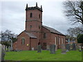
Holy Trinity Church, Wrockwardine Wood
Built in 1833 by an architect from Madeley, and Grade II listed https://britishlistedbuildings.co.uk/101351998-holy-trinity-church-wrockwardine-wood-and-trench#.XBvJk9SLTGg in 1983.
Image: © Richard Law
Taken: 20 Dec 2018
0.18 miles
8
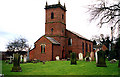
Holy Trinity Church, Wrockwardine Wood, Telford
Holy Trinity Church.
Image: © Gordon Cragg
Taken: 10 May 2003
0.19 miles
9
The Corner House
The Corner House, was once a Doctor's surgery, it still retains the original waiting room, and consulting room.
Image: © Paul Beaman
Taken: 25 May 2007
0.19 miles
10
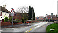
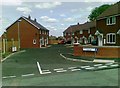
Church Road, Wrockwardine Wood, Telford
Church Road, Wrockwardine Wood, Telford looking South from opposite the churchyard.
Image: © Gordon Cragg
Taken: 16 Apr 2009
0.21 miles