IMAGES TAKEN NEAR TO
Talbot Close, TELFORD, TF2 7AP
Introduction
This page details the photographs taken nearby to Talbot Close, TF2 7AP by members of the Geograph project.
The Geograph project started in 2005 with the aim of publishing, organising and preserving representative images for every square kilometre of Great Britain, Ireland and the Isle of Man.

There are currently over 7.5m images from over14,400 individuals and you can help contribute to the project by visiting https://www.geograph.org.uk
Image Map
Images are licensed for reuse under creativecommons.org/licenses/by-sa/2.0
Notes
- Clicking on the map will re-center to the selected point.
- The higher the marker number, the further away the image location is from the centre of the postcode.
Image Listing (26 Images Found)
Images are licensed for reuse under creativecommons.org/licenses/by-sa/2.0
Image
Details
Distance
1
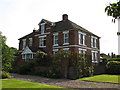
The Corner House
The Corner House, was once a Doctor's surgery, it still retains the original waiting room, and consulting room.
Image: © Paul Beaman
Taken: 25 May 2007
0.05 miles
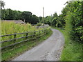
2
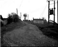
Wrockwardine Wood Inclined Plane, Shropshire
I regret I do not have an accurate grid reference for this photograph, but it certainly is inside the gridsquare SJ 7012. It shows the site of one of the inclined planes of the Shropshire high-level canal system in this area. The planes were used to transfer tub-boats (20ft x 6ft 3ins in size) from one level to another. The tub-boats were worked in 'gangs' of four, being managed by one man and one boy. They reached the main canal system by being lowered down the Tranch inclined plane, about 1 mile westwards from here. The canal line was easily traceable until the mid-1960s, but has now completely disappeared.
Image: © Dr Neil Clifton
Taken: 29 Apr 1967
0.08 miles
3
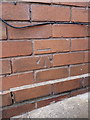
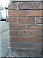
OS benchmark -Wrockwardine Wood, Furnace Lane
An OS cutmark on a house called Fairview; originally levelled at 104.16m above Ordnance Datum Newlyn.
Image: © Richard Law
Taken: 10 Aug 2014
0.09 miles
4
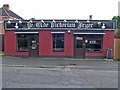
Award-winning Chip Shop
This humble building is home to a chip shop that has enjoyed a high reputation for decades. Years ago it was Percy Dean's and was famous for good quality then, but in 2007, under its new name it won county-wide acclaim.
Image: © Mike White
Taken: 11 Jul 2008
0.09 miles
5
Inclined Plane
Wrockwardine Wood Inclined Plane,a little overgrown nowadays.
Image: © Paul Beaman
Taken: 28 Jun 2007
0.10 miles
6
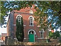
Wrockwardine Wood Methodist Church
The plaque reads:
Primitive Methodist Chapel, re-erected MDCCCLXIII [1863]
'The glory of this latter house shall be greater than of the former, saith the Lord of hosts' Haggai II IX
In September 2008 this former church was 'under offer' as a 'possible redevelopment opportunity', 'subject to planning'. I don't know what is proposed regarding the many well-maintained graves in front of it.
Image: © Mike White
Taken: 27 Sep 2008
0.10 miles
7
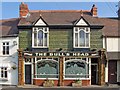
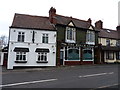
The Bull's Head, Wrockwardine Wood
With its green and russet tiles this must be the prettiest pub in Telford.
The oval plaque between the upper windows reads:
Est 1838 Bulls Head Renovated 1984
Image: © Mike White
Taken: 27 Sep 2008
0.10 miles
8
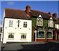
Bulls Head, Wrockwardine Wood
Freehouse noted for tiles and glass windows
Image: © al partington
Taken: 8 Feb 2006
0.11 miles
9
The Bull's Head Inn, Wrockwardine Wood
Built in the late 19th century, and fronted extensively with tiles from the Maws Tileworks at Coalport, The Bull's Head was renovated in 1984, very shortly after being Grade II listed https://britishlistedbuildings.co.uk/101033298-bulls-head-public-house-wrockwardine-wood-and-trench#.XBvLDdSLTGg the year before. The interior is also much tiled.
Image: © Richard Law
Taken: 20 Dec 2018
0.11 miles
10
OS benchmark - Wrockwardine Wood, New Road
An OS cutmark on a wall on the west side of New Road; originally levelled at 112.28m above Ordnance Datum Newlyn.
Image: © Richard Law
Taken: 10 Aug 2014
0.13 miles