IMAGES TAKEN NEAR TO
New Road, TELFORD, TF2 7AA
Introduction
This page details the photographs taken nearby to New Road, TF2 7AA by members of the Geograph project.
The Geograph project started in 2005 with the aim of publishing, organising and preserving representative images for every square kilometre of Great Britain, Ireland and the Isle of Man.

There are currently over 7.5m images from over14,400 individuals and you can help contribute to the project by visiting https://www.geograph.org.uk
Image Map
Images are licensed for reuse under creativecommons.org/licenses/by-sa/2.0
Notes
- Clicking on the map will re-center to the selected point.
- The higher the marker number, the further away the image location is from the centre of the postcode.
Image Listing (25 Images Found)
Images are licensed for reuse under creativecommons.org/licenses/by-sa/2.0
Image
Details
Distance
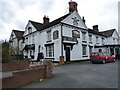
1
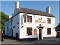
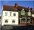
The Red Lion, Wrockwardine Wood
This pub is evidently thriving, though it's isolated in a truncated road: New Road, Wrockwardine Wood, which is cut by the B4373.
Image: © Mike White
Taken: 27 Sep 2008
0.01 miles
2
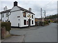
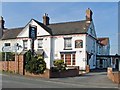
The Red Lion, New Road, Wrockwardine Wood
Image: © Richard Law
Taken: 12 Mar 2011
0.02 miles
4
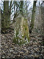
Cockshutt woods trig point
At 137m, and perched on the edge of a steep hill dropping northwards, this trig would have been visible for a long way in that direction before tree cover and outright neglect got the better of it.
Image: © Richard Law
Taken: 15 Jan 2011
0.08 miles
5
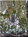
Benchmark bracket on trig point in Cockshutt woods
Image: © Richard Law
Taken: 15 Jan 2011
0.08 miles
6
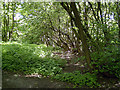
Old Canal Bed, Wrockwardine Woods, Telford
Old bed of the former canal that ran through "The Nabb" before descending, via an incline plane, to join the "Donnington Wood Canal" on its way to Lilleshall and Pave Lane..
Image: © Gordon Cragg
Taken: Unknown
0.09 miles
7
Bulls Head, Wrockwardine Wood
Freehouse noted for tiles and glass windows
Image: © al partington
Taken: 8 Feb 2006
0.13 miles
8
The White Horse
Behind the pub sign, the date on the gable is 1734.
Image: © Mike White
Taken: 27 Sep 2008
0.14 miles
10
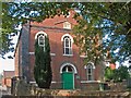
Wrockwardine Wood Methodist Church
The plaque reads:
Primitive Methodist Chapel, re-erected MDCCCLXIII [1863]
'The glory of this latter house shall be greater than of the former, saith the Lord of hosts' Haggai II IX
In September 2008 this former church was 'under offer' as a 'possible redevelopment opportunity', 'subject to planning'. I don't know what is proposed regarding the many well-maintained graves in front of it.
Image: © Mike White
Taken: 27 Sep 2008
0.15 miles