IMAGES TAKEN NEAR TO
Newlands Road, TELFORD, TF2 6NE
Introduction
This page details the photographs taken nearby to Newlands Road, TF2 6NE by members of the Geograph project.
The Geograph project started in 2005 with the aim of publishing, organising and preserving representative images for every square kilometre of Great Britain, Ireland and the Isle of Man.

There are currently over 7.5m images from over14,400 individuals and you can help contribute to the project by visiting https://www.geograph.org.uk
Image Map
Images are licensed for reuse under creativecommons.org/licenses/by-sa/2.0
Notes
- Clicking on the map will re-center to the selected point.
- The higher the marker number, the further away the image location is from the centre of the postcode.
Image Listing (121 Images Found)
Images are licensed for reuse under creativecommons.org/licenses/by-sa/2.0
Image
Details
Distance
1

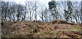
Newlands Road Estate, Oakengates
A very pleasant estate of private houses built on the site of the former John Maddocks iron foundry at Oakengates.
Image: © Gordon Cragg
Taken: 26 Mar 2009
0.04 miles
2
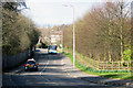
Station Road, Oakengates
Looking North towards Oakengate's centre, Station Road was at one time known as Quob Lane. The area to the right, now a housing estate behind the trees, was the site of Maddock's Iron Foundry, once one of the area's major employers and amongst the last of the local foundries to close.
Image: © Gordon Cragg
Taken: 26 Mar 2009
0.06 miles
4
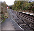
Railway towards Oakengates Tunnel
Viewed from the end of Oakengates railway station platform 1 looking along the route to Telford Central, Shifnal, Wolverhampton and Birmingham New Street. The tunnel is 430 metres long.
Image: © Jaggery
Taken: 9 Nov 2015
0.10 miles
5
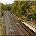
Oakengates Tunnel
This is the only tunnel on the Shrewsbury to Wolverhampton line.
At 430 metres it is the longest of the three railway tunnels currently in use in Shropshire.
Viewed from Oakengates station. Next station ahead is Telford Central.
Image: © Jaggery
Taken: 9 Nov 2015
0.10 miles
6

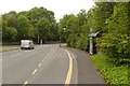
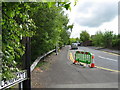
East along Hancocks Drive, Oakengates, Telford
Looking past Hancocks Drive houses towards Station Road houses in the background on the left.
Image: © Jaggery
Taken: 9 Nov 2015
0.11 miles
8
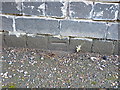
OS benchmark - Oakengates, Canongate railway bridge
This appears to be the datum line of an OS cutmark on the parapet of the Image over the former Coalport to Hadley coal mine line; originally levelled at 133.158m above Ordnance Datum Newlyn.
Image: © Richard Law
Taken: 10 Aug 2014
0.11 miles
9
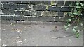
Canongate Bridge Benchmark
Ordnance Survey Benchmark - because the footpath has been re-surfaced on numerous occasions only the horizontal datum line is now visible
Image: © Anthony Rowley
Taken: 8 Apr 2021
0.11 miles