
IMAGES TAKEN NEAR TO
Kensington Way, TELFORD, TF2 6NA
Introduction
This page details the photographs taken nearby to Kensington Way, TF2 6NA by members of the Geograph project.
The Geograph project started in 2005 with the aim of publishing, organising and preserving representative images for every square kilometre of Great Britain, Ireland and the Isle of Man.

There are currently over 7.5m images from over14,400 individuals and you can help contribute to the project by visiting https://www.geograph.org.uk
Image Map
Images are licensed for reuse under creativecommons.org/licenses/by-sa/2.0
Notes
- Clicking on the map will re-center to the selected point.
- The higher the marker number, the further away the image location is from the centre of the postcode.
Image Listing (244 Images Found)
Images are licensed for reuse under creativecommons.org/licenses/by-sa/2.0
Image
Details
Distance
1
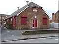
The former Parish Hall of Wombridge
Built, according to the stone in the gable, in 1835, this now appears to be the offices or stores of a local scaffolding firm.
Image: © Richard Law
Taken: 12 Mar 2011
0.03 miles
2
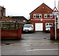
G.Leddington Electrical Ltd, Telford
Premises at 15 Church Parade, facing Leonard Street. http://www.geograph.org.uk/photo/4733924
The warning sign on the right shows that there are speed humps across
the road for 400 yards to the right and 80 yards to the left.
Image: © Jaggery
Taken: 9 Nov 2015
0.03 miles
3
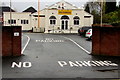
Guru Nanak Darbar Sikh Gurdwara, Oakengates, Telford
The origins of the religion Sikhism date from the 15th century, when it was founded in the Punjab, India.
There are now more than 20 million Sikhs worldwide, with more than 300,000 in the UK. There are gurdwaras (temples) in many parts of Britain, including two in Telford. This one is set back from the west side of Church Parade in the Oakengates area of Telford.
Image: © Jaggery
Taken: 9 Nov 2015
0.03 miles
4
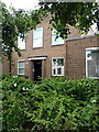
Exchange House
Originally the local Labour Exchange offices, an organisation which gradually morphed over the years from the Government-run Labour Exchange, to Employment Exchanges, to Jobcentres, and finally to JobcentrePlus. This particular building has been converted to flats.
Image: © Richard Law
Taken: 5 Jul 2014
0.03 miles
5
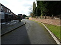
WSW along Kensington Way
A quiet cul-de-sac of modern housing in Oakengates.
Image: © Richard Law
Taken: 10 Mar 2023
0.04 miles
6

Former Wombridge Parish Hall for sale, Telford
Viewed across New Street in early November 2015.
A For Sale board shows that the building could be used as a trade counter store or for residential development.
The inscription on the stone tablet above the door is WOMBRIDGE PARISH HALL 1935.
Image: © Jaggery
Taken: 9 Nov 2015
0.05 miles
7
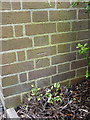
OS benchmark - Oakengates, Employment Exchange
An OS benchmark on the outside wall of the (former) Employment Exchange in New Street; originally levelled in 1961 at 111.377m above Ordnance Datum Newlyn.
Image: © Richard Law
Taken: 5 Jul 2014
0.05 miles
8
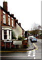
Oakengates boundary sign, Telford
Looking into the northern edge of the Oakengates area of Telford
from the southern edge of the Wombridge area.
The Telford Oakengates sign is on the corner of Leonard Street and New Street.
Image: © Jaggery
Taken: 9 Nov 2015
0.05 miles
9

End of the 20 zone, New Street, Oakengates, Telford
A few metres north of the Slaney Street junction, http://www.geograph.org.uk/photo/4736958 the 20mph speed limit on New Street increases to 30.
Image: © Jaggery
Taken: 9 Nov 2015
0.06 miles
10
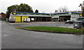
ATS Euromaster, Oakengates, Telford
Viewed across Kensington Way, on the west side of New Street in the Oakengates area of Telford.
ATS Euromaster sells tyres, exhausts, brakes etc, and provides motor vehicle servicing.
Image: © Jaggery
Taken: 9 Nov 2015
0.06 miles