IMAGES TAKEN NEAR TO
Lincoln Road, TELFORD, TF2 6LN
Introduction
This page details the photographs taken nearby to Lincoln Road, TF2 6LN by members of the Geograph project.
The Geograph project started in 2005 with the aim of publishing, organising and preserving representative images for every square kilometre of Great Britain, Ireland and the Isle of Man.

There are currently over 7.5m images from over14,400 individuals and you can help contribute to the project by visiting https://www.geograph.org.uk
Image Map
Images are licensed for reuse under creativecommons.org/licenses/by-sa/2.0
Notes
- Clicking on the map will re-center to the selected point.
- The higher the marker number, the further away the image location is from the centre of the postcode.
Image Listing (17 Images Found)
Images are licensed for reuse under creativecommons.org/licenses/by-sa/2.0
Image
Details
Distance
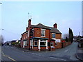
1
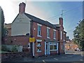
The Fountains Inn, Wrockwardine Wood
Is there something strange about the sky over this pub? See Image!
Image: © Mike White
Taken: 27 Sep 2008
0.11 miles
2
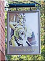
Fountain Inn pub sign
They've got a new sign since Image
Image: © Mike White
Taken: 27 Sep 2008
0.11 miles
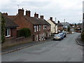
3
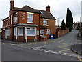
The Fountain Inn, Wrockwardine Wood
Very little changed in the 5 years since http://www.geograph.org.uk/photo/138267 was taken, apart from a new hanging sign outside.
Image: © Richard Law
Taken: 12 Mar 2011
0.11 miles
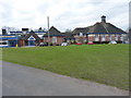
4
The Fountains Inn, Wrockwardine Wood
Former Marstons pub
Image: © al partington
Taken: 15 Mar 2006
0.11 miles
5
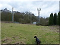
Reservoir and phone masts, Wrockwardine Wood
A grass-covered reservoir, built into what feels like one of the many old pit mounds of north Telford, in this case near to Wrockwardine Wood.
Image: © Richard Law
Taken: 12 Mar 2011
0.12 miles
8
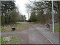
Silkin Way, Wrockwardine Wood
Part of the long-distance (OK, not that long) path through the centre of Telford - the Silkin Way is a 13-mile route from the Ironbridge Gorge to Bratton. The characteristic waymarks are these railway wagon wheels (another at http://www.geograph.org.uk/photo/855343)
Image: © Richard Law
Taken: 12 Mar 2011
0.18 miles
9
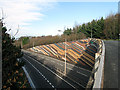
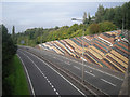
Retaining Wall A442 looking North-East
The retaining wall at the side of the A442 Eastern Primary Road (Queensway) at Oakengates, Telford. The pattern represents, fairly accurately, the geological formations under the hill.Image
Image: © Gordon Cragg
Taken: 17 Jan 2009
0.18 miles