IMAGES TAKEN NEAR TO
Cockshutt Road, TELFORD, TF2 6LD
Introduction
This page details the photographs taken nearby to Cockshutt Road, TF2 6LD by members of the Geograph project.
The Geograph project started in 2005 with the aim of publishing, organising and preserving representative images for every square kilometre of Great Britain, Ireland and the Isle of Man.

There are currently over 7.5m images from over14,400 individuals and you can help contribute to the project by visiting https://www.geograph.org.uk
Image Map
Images are licensed for reuse under creativecommons.org/licenses/by-sa/2.0
Notes
- Clicking on the map will re-center to the selected point.
- The higher the marker number, the further away the image location is from the centre of the postcode.
Image Listing (22 Images Found)
Images are licensed for reuse under creativecommons.org/licenses/by-sa/2.0
Image
Details
Distance
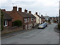
1
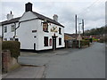
The Red Lion, New Road, Wrockwardine Wood
Image: © Richard Law
Taken: 12 Mar 2011
0.07 miles
2
Old Canal Bed, Wrockwardine Woods, Telford
Old bed of the former canal that ran through "The Nabb" before descending, via an incline plane, to join the "Donnington Wood Canal" on its way to Lilleshall and Pave Lane..
Image: © Gordon Cragg
Taken: Unknown
0.07 miles
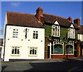
3
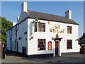
The Red Lion, Wrockwardine Wood
This pub is evidently thriving, though it's isolated in a truncated road: New Road, Wrockwardine Wood, which is cut by the B4373.
Image: © Mike White
Taken: 27 Sep 2008
0.07 miles
5
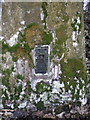
Benchmark bracket on trig point in Cockshutt woods
Image: © Richard Law
Taken: 15 Jan 2011
0.09 miles
6
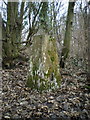
Cockshutt woods trig point
At 137m, and perched on the edge of a steep hill dropping northwards, this trig would have been visible for a long way in that direction before tree cover and outright neglect got the better of it.
Image: © Richard Law
Taken: 15 Jan 2011
0.09 miles
8
Bulls Head, Wrockwardine Wood
Freehouse noted for tiles and glass windows
Image: © al partington
Taken: 8 Feb 2006
0.18 miles
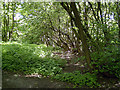
9
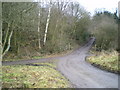
Bridleway and track crossing in Cockshutt woods
The track ahead leads up to a large house in the woods; it's also a bridleway to the top of the hill.
Image: © Richard Law
Taken: 15 Jan 2011
0.18 miles
10
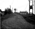
Wrockwardine Wood Inclined Plane, Shropshire
I regret I do not have an accurate grid reference for this photograph, but it certainly is inside the gridsquare SJ 7012. It shows the site of one of the inclined planes of the Shropshire high-level canal system in this area. The planes were used to transfer tub-boats (20ft x 6ft 3ins in size) from one level to another. The tub-boats were worked in 'gangs' of four, being managed by one man and one boy. They reached the main canal system by being lowered down the Tranch inclined plane, about 1 mile westwards from here. The canal line was easily traceable until the mid-1960s, but has now completely disappeared.
Image: © Dr Neil Clifton
Taken: 29 Apr 1967
0.19 miles