IMAGES TAKEN NEAR TO
Wombridge Road, TELFORD, TF2 6JB
Introduction
This page details the photographs taken nearby to Wombridge Road, TF2 6JB by members of the Geograph project.
The Geograph project started in 2005 with the aim of publishing, organising and preserving representative images for every square kilometre of Great Britain, Ireland and the Isle of Man.

There are currently over 7.5m images from over14,400 individuals and you can help contribute to the project by visiting https://www.geograph.org.uk
Image Map
Images are licensed for reuse under creativecommons.org/licenses/by-sa/2.0
Notes
- Clicking on the map will re-center to the selected point.
- The higher the marker number, the further away the image location is from the centre of the postcode.
Image Listing (27 Images Found)
Images are licensed for reuse under creativecommons.org/licenses/by-sa/2.0
Image
Details
Distance
1
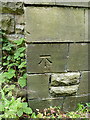
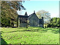
OS benchmark - Wombridge, St Mary & St Leonards church
An OS cutmark at the base of the SE buttress of the church; originally levelled in 1962 at 101.495m above Ordnance Datum Newlyn.
Image: © Richard Law
Taken: 5 Jul 2014
0.03 miles
2
Abbey Walls, Wombridge
Abbey Walls, and a number of nearby streets such as Priory Road and The Cloisters, are so named because this area just south of the Image was once host to an Augustinian Priory. It is marked (as 'Site of Augustinian Priory') together with Wombridge Farm, on the early OS maps dated 1882, 1901, 1927 and even as late as 1948, but by the time that Telford was being developed as a New Town in the 1960s, much of the above-ground remains (if any) would have been erased from the site. There is an area just east of the church which is designated as a Scheduled Monument https://historicengland.org.uk/listing/the-list/list-entry/1020661 where some remains of the Lady Chapel are still visible. Much of the surrounding area was a mish-mash of ironworks, collieries, pits, shafts and mines up to that point, and the Development Corporation's mission was to turn much of it to residential use. A fair amount of the archaeology probably went west at the same time.
Image: © Richard Law
Taken: 3 Nov 2023
0.03 miles
3
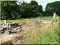
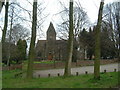
St Leonard's Priory, Wombridge
Little remains above ground of this Augustinian Priory, founded in the 12th century by the local family - William de Hadley and his wife Seburga, and their sons Alan of Hadley & William of Ercall. It was built, mainly in the 13th century, using stone from a quarry in Grindle just south of Shifnal, and later a quarry at Ketley.
The priory lasted into the 16th century, being dissolved in 1536, at which point the movable goods were sold off, along with the church bells and a quantity of lead, presumably from the roof. Some rights to coal mines and grazing land were transferred to a William Abbot for 20 years following that, before being taken on by a James Leveson. Most of the stone from the buildings would then have been removed from site ('robbed out') for other construction work, leaving just a few rough walls and a doorway to stand above ground until the 19th century.
The priory and its associated buildings would originally have covered a large area to the north and east of the present church, but much was destroyed (or at least covered over) during the 1960s when the present roads and housing estates were built. What we see here is known as the Lady Chapel, and includes the bases of a number of stone pillars. A small-scale archaeological investigation in 2012 re-discovered these walls and foundations that had last been seen in the 1930s, and uncovered the remains of the medieval floor.
Image: © Richard Law
Taken: 5 Jul 2014
0.03 miles
4
Church of St Mary & St Leonard, Wombridge
The church is shown on the 1:2500 map of 1882, at which time much of the surrounding area was riddled with collieries, mines, pits, ironworks and the like. It was first built in timber, as a replacement for the nearby priory's Lady Chapel, in the 1750s, but was then rebuilt in stone in the 19th century, and presumably this is the building we see today. There are some remains of the Augustinian Priory and its Lady Chapel in the grounds, which were designated as a Scheduled Monument in 1960 https://historicengland.org.uk/listing/the-list/list-entry/1020661
Image: © Richard Law
Taken: 3 Nov 2023
0.04 miles
5

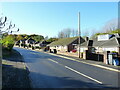
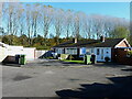
The northern end of Priory Road in Wombridge
Image: © Richard Law
Taken: 3 Nov 2023
0.06 miles
6
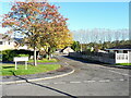
The Cloisters, Wombridge
This small cul-de-sac, and a number of nearby residential streets such as Abbey Walls and The Cloisters, are so named because this area just south of the Image was once host to an Augustinian Priory. It is marked (as 'Site of Augustinian Priory') together with Wombridge Farm, on the early OS maps dated 1882, 1901, 1927 and even as late as 1948, but by the time that Telford was being developed as a New Town in the 1960s, much of the above-ground remains (if any) would have been erased from the site. There is an area just east of the church which is designated as a Scheduled Monument https://historicengland.org.uk/listing/the-list/list-entry/1020661 where some remains of the Lady Chapel are still visible. Much of the surrounding area was a mish-mash of ironworks, collieries, pits, shafts and mines up to that point, and the Development Corporation's mission was to turn much of it to residential use. A fair amount of the archaeology probably went west at the same time.
Image: © Richard Law
Taken: 3 Nov 2023
0.06 miles
7
Wombridge Parish Church
Read all about its history here: http://www.oakengates.com/religion/a_history_of_wombridge_parish_ch.htm
Image: © Steve McShane
Taken: 15 Apr 2006
0.08 miles
8
Priory Road, Wombridge
Priory Road, and a number of nearby residential streets such as Abbey Walls and The Cloisters, are so named because this area just south of the Image was once host to an Augustinian Priory. It is marked (as 'Site of Augustinian Priory') together with Wombridge Farm, on the early OS maps dated 1882, 1901, 1927 and even as late as 1948, but by the time that Telford was being developed as a New Town in the 1960s, much of the above-ground remains (if any) would have been erased from the site. There is an area just east of the church which is designated as a Scheduled Monument https://historicengland.org.uk/listing/the-list/list-entry/1020661 where some remains of the Lady Chapel are still visible. Much of the surrounding area was a mish-mash of ironworks, collieries, pits, shafts and mines up to that point, and the Development Corporation's mission was to turn much of it to residential use. A fair amount of the archaeology probably went west at the same time.
Image: © Richard Law
Taken: 3 Nov 2023
0.10 miles
9

Abbots Close, Wombridge
Abbots Close, together with Priory Road, and a number of other nearby residential streets such as Abbey Walls and The Cloisters, are so named because the area just south of the Image was once the site of an Augustinian Priory. It is marked (as 'Site of Augustinian Priory') together with Wombridge Farm, on the early OS maps dated 1882, 1901, 1927 and even as late as 1948, but by the time that Telford was being developed as a New Town in the 1960s, much of the above-ground remains (if any) would have been erased from the site. There is an area just east of the church which is designated as a Scheduled Monument https://historicengland.org.uk/listing/the-list/list-entry/1020661 where some remains of the Lady Chapel are still visible. Much of the surrounding area was a mish-mash of ironworks, collieries, pits, shafts and mines up to that point, and the Development Corporation's mission was to turn much of it to residential use. A fair amount of the archaeology probably went west at the same time.
Image: © Richard Law
Taken: 3 Nov 2023
0.10 miles