IMAGES TAKEN NEAR TO
Hadley Road, TELFORD, TF2 6HJ
Introduction
This page details the photographs taken nearby to Hadley Road, TF2 6HJ by members of the Geograph project.
The Geograph project started in 2005 with the aim of publishing, organising and preserving representative images for every square kilometre of Great Britain, Ireland and the Isle of Man.

There are currently over 7.5m images from over14,400 individuals and you can help contribute to the project by visiting https://www.geograph.org.uk
Image Map
Images are licensed for reuse under creativecommons.org/licenses/by-sa/2.0
Notes
- Clicking on the map will re-center to the selected point.
- The higher the marker number, the further away the image location is from the centre of the postcode.
Image Listing (33 Images Found)
Images are licensed for reuse under creativecommons.org/licenses/by-sa/2.0
Image
Details
Distance
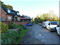
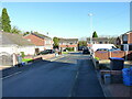
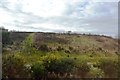
3
Abbots Close, Wombridge
Abbots Close, together with Priory Road, and a number of other nearby residential streets such as Abbey Walls and The Cloisters, are so named because the area just south of the Image was once the site of an Augustinian Priory. It is marked (as 'Site of Augustinian Priory') together with Wombridge Farm, on the early OS maps dated 1882, 1901, 1927 and even as late as 1948, but by the time that Telford was being developed as a New Town in the 1960s, much of the above-ground remains (if any) would have been erased from the site. There is an area just east of the church which is designated as a Scheduled Monument https://historicengland.org.uk/listing/the-list/list-entry/1020661 where some remains of the Lady Chapel are still visible. Much of the surrounding area was a mish-mash of ironworks, collieries, pits, shafts and mines up to that point, and the Development Corporation's mission was to turn much of it to residential use. A fair amount of the archaeology probably went west at the same time.
Image: © Richard Law
Taken: 3 Nov 2023
0.06 miles
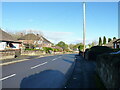
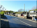
4
Railway bridge over Hadley Road
The Wolverhampton to Shrewsbury line crosses Hadley Road just outside Oakengates
Image: © Richard Law
Taken: 3 Nov 2023
0.11 miles
5
Abbots Close, Wombridge
Abbots Close, together with Priory Road, and a number of other nearby residential streets such as Abbey Walls and The Cloisters, are so named because the area just south of the Image was once the site of an Augustinian Priory. It is marked (as 'Site of Augustinian Priory') together with Wombridge Farm, on the early OS maps dated 1882, 1901, 1927 and even as late as 1948, but by the time that Telford was being developed as a New Town in the 1960s, much of the above-ground remains (if any) would have been erased from the site. There is an area just east of the church which is designated as a Scheduled Monument https://historicengland.org.uk/listing/the-list/list-entry/1020661 where some remains of the Lady Chapel are still visible. Much of the surrounding area was a mish-mash of ironworks, collieries, pits, shafts and mines up to that point, and the Development Corporation's mission was to turn much of it to residential use. A fair amount of the archaeology probably went west at the same time.
Image: © Richard Law
Taken: 3 Nov 2023
0.11 miles
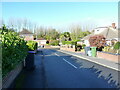
7
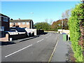
The northern end of Priory Road in Wombridge
Image: © Richard Law
Taken: 3 Nov 2023
0.15 miles
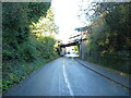
8
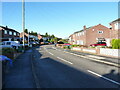
Priory Road, Wombridge
Priory Road, and a number of nearby residential streets such as Abbey Walls and The Cloisters, are so named because this area just south of the Image was once host to an Augustinian Priory. It is marked (as 'Site of Augustinian Priory') together with Wombridge Farm, on the early OS maps dated 1882, 1901, 1927 and even as late as 1948, but by the time that Telford was being developed as a New Town in the 1960s, much of the above-ground remains (if any) would have been erased from the site. There is an area just east of the church which is designated as a Scheduled Monument https://historicengland.org.uk/listing/the-list/list-entry/1020661 where some remains of the Lady Chapel are still visible. Much of the surrounding area was a mish-mash of ironworks, collieries, pits, shafts and mines up to that point, and the Development Corporation's mission was to turn much of it to residential use. A fair amount of the archaeology probably went west at the same time.
Image: © Richard Law
Taken: 3 Nov 2023
0.16 miles
10
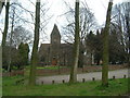
Wombridge Parish Church
Read all about its history here: http://www.oakengates.com/religion/a_history_of_wombridge_parish_ch.htm
Image: © Steve McShane
Taken: 15 Apr 2006
0.17 miles