IMAGES TAKEN NEAR TO
Hayward Parade, TELFORD, TF2 6EZ
Introduction
This page details the photographs taken nearby to Hayward Parade, TF2 6EZ by members of the Geograph project.
The Geograph project started in 2005 with the aim of publishing, organising and preserving representative images for every square kilometre of Great Britain, Ireland and the Isle of Man.

There are currently over 7.5m images from over14,400 individuals and you can help contribute to the project by visiting https://www.geograph.org.uk
Image Map
Images are licensed for reuse under creativecommons.org/licenses/by-sa/2.0
Notes
- Clicking on the map will re-center to the selected point.
- The higher the marker number, the further away the image location is from the centre of the postcode.
Image Listing (87 Images Found)
Images are licensed for reuse under creativecommons.org/licenses/by-sa/2.0
Image
Details
Distance
2
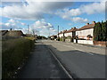
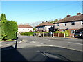
Convenience store on the corner of Church Parade and Hayward Parade
Local facilities in the middle of a large housing estate in Oakengates.
Image: © Richard Law
Taken: 10 Mar 2023
0.02 miles
3
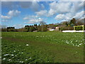
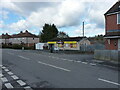
Recreation ground east of Wombridge
A large play area in the middle of extensive housing between the Oakengates and Wombridge areas of Telford.
Image: © Richard Law
Taken: 10 Mar 2023
0.05 miles
4
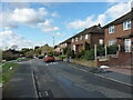
Pavement parking on Maurice Lee Avenue
I make little comment, except to say I think it's unforgivably inconsiderate in almost all cases.
Image: © Richard Law
Taken: 10 Mar 2023
0.06 miles
6
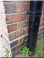
OS benchmark - Wombridge, 12 Maurice Lee Avenue
An OS cutmark on the east angle of no 12 Maurice Lee Ave; originally levelled in 1961 at 110.694m above Ordnance Datum Newlyn.
Image: © Richard Law
Taken: 5 Jul 2014
0.09 miles
7
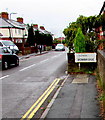
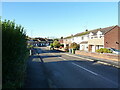
Wombridge boundary sign, Telford
Looking into the southern edge of the Wombridge area of Telford
from the northern edge of the Oakengates area. The road is Church Parade.
Image: © Jaggery
Taken: 9 Nov 2015
0.09 miles
8
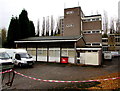
Oakengates Telephone Exchange, Telford
The exchange, identifier WNOAK, is on the east side of Church Parade in the Oakengates area of Telford.
Image: © Jaggery
Taken: 9 Nov 2015
0.10 miles
9
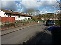
Withington Close, Wombridge
Housing from (probably) the late 1950s or early 1960s in the Wombridge area of Telford.
Image: © Richard Law
Taken: 10 Mar 2023
0.11 miles
10
Houses on Priory Road
Priory Road, and a number of nearby residential streets such as Abbey Walls and The Cloisters, are so named because this area just south of the Image was once host to an Augustinian Priory. It is marked (as 'Site of Augustinian Priory') together with Wombridge Farm, on the early OS maps dated 1882, 1901, 1927 and even as late as 1948, but by the time that Telford was being developed as a New Town in the 1960s, much of the above-ground remains (if any) would have been erased from the site. There is an area just east of the church which is designated as a Scheduled Monument https://historicengland.org.uk/listing/the-list/list-entry/1020661 where some remains of the Lady Chapel are still visible. Much of the surrounding area was a mish-mash of ironworks, collieries, pits, shafts and mines up to that point, and the Development Corporation's mission was to turn much of it to residential use. A fair amount of the archaeology probably went west at the same time.
Image: © Richard Law
Taken: 3 Nov 2023
0.11 miles