IMAGES TAKEN NEAR TO
Charlton Street, TELFORD, TF2 6BP
Introduction
This page details the photographs taken nearby to Charlton Street, TF2 6BP by members of the Geograph project.
The Geograph project started in 2005 with the aim of publishing, organising and preserving representative images for every square kilometre of Great Britain, Ireland and the Isle of Man.

There are currently over 7.5m images from over14,400 individuals and you can help contribute to the project by visiting https://www.geograph.org.uk
Image Map
Images are licensed for reuse under creativecommons.org/licenses/by-sa/2.0
Notes
- Clicking on the map will re-center to the selected point.
- The higher the marker number, the further away the image location is from the centre of the postcode.
Image Listing (209 Images Found)
Images are licensed for reuse under creativecommons.org/licenses/by-sa/2.0
Image
Details
Distance
1
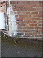
OS benchmark - Ketley Bank/Oakengates, 48 Holyhead Road
An OS cutmark on the side wall of the building (facing into Church Street, rather than the old A5 Holyhead Road); originally levelled in 1960 at 137.962m above Ordnance Datum Newlyn
Image: © Richard Law
Taken: 21 Feb 2015
0.04 miles
2
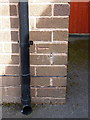
OS benchmark - Oakengates, 15 Church St
An OS cutmark on the front face of no 15 Church Street; originally levelled in 1985 at 127.079m above Ordnance Datum Newlyn.
Image: © Richard Law
Taken: 5 Jul 2014
0.04 miles
3
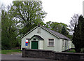
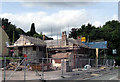
Church Hall, Oakengates
The Holy Trinity Church Hall, Holyhead Road, Oakengates. This is up sale with outline planning permission for housing. It is hoped to raise enough money to enable the re-furbishment of the interior of the adjoining church. It would appear that a sale was proceeding, until the surveyors found a couple of mine shafts on the site that will require capping. Ooopps!
Image
Image: © Gordon Cragg
Taken: 24 Apr 2009
0.06 miles
4
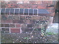
OS bench mark on Holy Trinity Church
Ordnance Survey bench mark with bolt on the south-east corner of the south transept of Holy Trinity Church, Oakengates. This bench mark was established during the First primary levelling of England & Wales (1840-1860), and was levelled with a height of 453.1560 feet [138.1219 metres] above mean sea level (Liverpool datum). It was included on the Llandysilio to Stafford levelling line. The surveyor's description was "No. 61. Bolt in South-east corner of South transept of Trinity Church, Oaken Gate ; 1.52 ft. above surface." (p.587)
Image: © Shantavira
Taken: 6 May 2014
0.06 miles
5
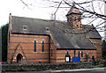
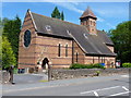
Holy Trinity Church, Oakengates
Oakengates parish church, Holy Trinity, on the Holyhead Road, Oakengates (the former A5).
Image: © Gordon Cragg
Taken: 31 Jan 2009
0.07 miles
6
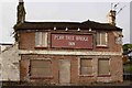
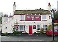
Pear Tree Bridge Inn
Happily it's being renovated and looks odd with the stucco stripped off some rather untidy, but venerable, brickwork. When it was open it looked like this: Image
Image: © Mike White
Taken: 17 May 2009
0.07 miles
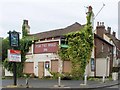
8
Former Pear Tree Bridge Inn, Oakengates
The conversion of the old Pear Tree Bridge Inn, on Holyhead Road, into flats is steaming ahead. They appear to be retaining as much of the old character as possible. Hope they keep the Inn Sign, would be a shame to see it go.
The pub in better times---Image
Image: © Gordon Cragg
Taken: 8 Aug 2009
0.08 miles
9
The Pear Tree Bridge. Holyhead Road, Oakengates
The Pear Tree pub as it was in 2003.
Before the Holyhead Road was built in the 1820s, this was the route of the Ketley Canal which ran from a junction with the Shropshire Canal to the iron foundries at Ketley. The district was well known for the many fruit orchards that existed before it was covered with coalpits and waste heaps. http://NE-Telford-Pubs.fotopic.net
Image: © Gordon Cragg
Taken: 11 Mar 2003
0.08 miles
10
Pear Tree Bridge Inn
The Pear Tree Bridge Inn on the old A5 (B5061) awaits its fate.
Image: © Mike White
Taken: 26 May 2008
0.08 miles