IMAGES TAKEN NEAR TO
Beveley Road, TELFORD, TF2 6AU
Introduction
This page details the photographs taken nearby to Beveley Road, TF2 6AU by members of the Geograph project.
The Geograph project started in 2005 with the aim of publishing, organising and preserving representative images for every square kilometre of Great Britain, Ireland and the Isle of Man.

There are currently over 7.5m images from over14,400 individuals and you can help contribute to the project by visiting https://www.geograph.org.uk
Image Map
Images are licensed for reuse under creativecommons.org/licenses/by-sa/2.0
Notes
- Clicking on the map will re-center to the selected point.
- The higher the marker number, the further away the image location is from the centre of the postcode.
Image Listing (43 Images Found)
Images are licensed for reuse under creativecommons.org/licenses/by-sa/2.0
Image
Details
Distance
1
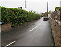
Hill Top Road, Oakengates, Telford
Dead-end residential road viewed from the corner of Beveley Road which I thought
was Beverley Road until a second glance at a nearby name sign confirmed that it's Beveley.
Image: © Jaggery
Taken: 9 Nov 2015
0.00 miles
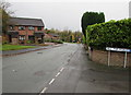
2
Eastern end of Beveley Road, Oakengates, Telford
Looking west along Beveley (not Beverley) Road from the edge of Hartshill.
Image: © Jaggery
Taken: 9 Nov 2015
0.02 miles
3
West along Beveley Road, Oakengates, Telford
From the corner of Hill Top Road. The name sign next to the
Hill Top Road name sign confirms that it's Beveley Road not Beverley Road.
Image: © Jaggery
Taken: 9 Nov 2015
0.03 miles
4
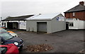
Hartshill Car Care and Shropshire Bearings, Oakengates, Telford
Set back from the north side of the road named Hartshill.
Image: © Jaggery
Taken: 9 Nov 2015
0.06 miles
5
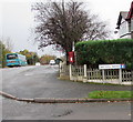
Corner of Hartshill Avenue and Hartshill, Oakengates, Telford
The postbox http://www.geograph.org.uk/photo/4735137 is attached to a short wooden post in a suburban garden.
Image: © Jaggery
Taken: 9 Nov 2015
0.07 miles
6
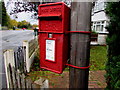
Queen Elizabeth II postbox on a pole in a suburban garden, Oakengates, Telford
Located here. http://www.geograph.org.uk/photo/4735152
Image: © Jaggery
Taken: 9 Nov 2015
0.07 miles
7
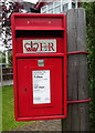
Elizabeth II postbox on Hartshill, Telford
Postbox No. TF2 88.
See Image] for context.
Image: © JThomas
Taken: 18 May 2019
0.07 miles
8
BT phonebox on a Hartshill corner, Telford
On the corner of Hartshill Avenue and Hartshill.
Image: © Jaggery
Taken: 9 Nov 2015
0.08 miles
9
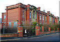
Walker Technical College, Oakengates. (Closed)
The Old Walker Technical College, Oakengates, built in 1927. A well loved place of learning for many years, it is now closed and awaiting its fate.
Developers wish to convert the building into apartments and make changes to the structure; they are in discussion with the local borough council but they seem unable to come to an agreement about the details.
With the present economic conditions it appears doubtful that the building can be saved.
Image: © Gordon Cragg
Taken: 20 Jan 2009
0.08 miles
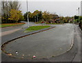
10
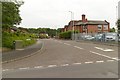
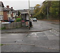
Hartsbridge Road
At the junction with Hartshill.
Image: © Mark Anderson
Taken: 18 Jun 2019
0.08 miles