IMAGES TAKEN NEAR TO
John Rushton Drive, TF2 5AE
Introduction
This page details the photographs taken nearby to John Rushton Drive, TF2 5AE by members of the Geograph project.
The Geograph project started in 2005 with the aim of publishing, organising and preserving representative images for every square kilometre of Great Britain, Ireland and the Isle of Man.

There are currently over 7.5m images from over14,400 individuals and you can help contribute to the project by visiting https://www.geograph.org.uk
Image Map
Images are licensed for reuse under creativecommons.org/licenses/by-sa/2.0
Notes
- Clicking on the map will re-center to the selected point.
- The higher the marker number, the further away the image location is from the centre of the postcode.
Image Listing (23 Images Found)
Images are licensed for reuse under creativecommons.org/licenses/by-sa/2.0
Image
Details
Distance
1
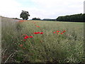
Poppies in a field of rape, Priorslee
Not the huge swathe of wild poppies that sometimes occurs in crop fields, but a good display nonetheless.
Image: © Richard Law
Taken: 7 Jun 2020
0.03 miles
3
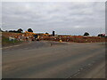
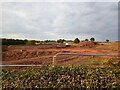
Entrance to a new housing site
The next phase of the ever-growing Priorslee housing estate has broken ground in recent weeks in the area between Castle Farm Way (foreground) and Woodhouse Lane. This is the entrance to the site, which will build on the field, and several others, which were photographed a year ago in Image
Image: © Richard Law
Taken: 16 Oct 2021
0.10 miles
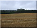
4
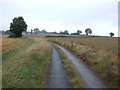
National Cycle Route 81 towards Telford
A little used road through arable land.
Image: © JThomas
Taken: 10 Aug 2019
0.10 miles
5
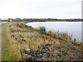
Priorslee Lake
Balancing reservoir operated by Severn Trent Water, next to Castle Farm Way: http://friendsofpriorsleelake.blogspot.co.uk/p/latest-sightings.html
Image: © Mike Faherty
Taken: 14 Oct 2014
0.11 miles
6
New housing development off Castle Farm Way
The next phase of the ever-growing Priorslee housing estate has broken ground in recent weeks in the area between Castle Farm Way and the formerly very quiet Woodhouse Lane. This will build on the field, and several others, which were photographed a year ago in Image
Image: © Richard Law
Taken: 16 Oct 2021
0.12 miles
8
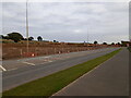
New housing development near Priorslee
The next phase of the ever-growing Priorslee housing estate has broken ground in recent weeks in the area between Castle Farm Way (foreground) and Woodhouse Lane. This will build on the field, and several others, which were photographed a year ago in Image
Image: © Richard Law
Taken: 16 Oct 2021
0.13 miles
9
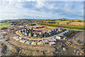
New homes being constructed in Priorslee
A new housing development being built.
Image: © Andrew Abbott
Taken: 16 Mar 2020
0.14 miles
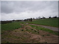
10
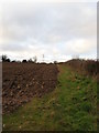
Open Plough and Hedgerow
Getting ready for the next crop!
Image: © Paul Beaman
Taken: 21 Dec 2008
0.17 miles