IMAGES TAKEN NEAR TO
Churchill Drive, TELFORD, TF2 0BT
Introduction
This page details the photographs taken nearby to Churchill Drive, TF2 0BT by members of the Geograph project.
The Geograph project started in 2005 with the aim of publishing, organising and preserving representative images for every square kilometre of Great Britain, Ireland and the Isle of Man.

There are currently over 7.5m images from over14,400 individuals and you can help contribute to the project by visiting https://www.geograph.org.uk
Image Map
Images are licensed for reuse under creativecommons.org/licenses/by-sa/2.0
Notes
- Clicking on the map will re-center to the selected point.
- The higher the marker number, the further away the image location is from the centre of the postcode.
Image Listing (59 Images Found)
Images are licensed for reuse under creativecommons.org/licenses/by-sa/2.0
Image
Details
Distance
2
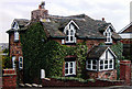
"Duke of Sutherland" Cottage, Main Road, Ketley Bank, Oakengates
A typical "Duke of Sutherland" cottage, would appear to be a "house style" for the Lilleshall Company of Shropshire. There are many examples in this area.
Image: © Gordon Cragg
Taken: 21 Jan 2006
0.07 miles
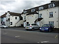
3
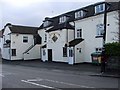
The Stafford Arms, Ketley Bank
Quite a big pub but closed at lunchtime when I walked past.
Image: © Mike White
Taken: 14 Jan 2009
0.08 miles
4
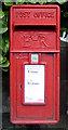
Another Wall Post Box. Ketley Bank, Telford
An ER II box on Main Road, Ketley Bank,Telford, outside the Stafford Arms Pub.
Image: © Gordon Cragg
Taken: 19 Dec 2008
0.10 miles
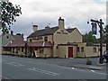
6
The Stafford Arms
It's not entirely clear whether this establishment is still trading. It looks a little run down since Image was taken in early 2009.
Image: © Richard Law
Taken: 10 Aug 2014
0.11 miles
7

The Holyhead Road, Oakengates
The Holyhead Road looking Southeastwards towards the Greyhound Roundabout.
Image: © Gordon Cragg
Taken: 14 Feb 2009
0.11 miles
8
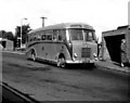
Hartshill Bus station, Oakengates
Although only a small town, Oakengates had, in the 1960s, two small bus stations. Here in the Hartshill station, a Bedford of G. Cooper waits with a local service to Priorslee. It is a pity this picture was in black and white, as Cooper used a brilliant orange livery, with a brown stripe.
Image: © Dr Neil Clifton
Taken: 31 Aug 1963
0.12 miles
9
The Hare and Hounds, Ketley
This pub is on the 1889 map, named the Omnibus. It was extended and renamed a few years ago, replacing real history with false. The old two-storey building stands above a clutter of added dining rooms on the left and lavatories on the right.
The unwisdom of changing a pub's name can be seen on the sign outside Image
Image: © Mike White
Taken: 2 Sep 2008
0.13 miles
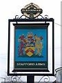
10
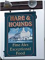
Hare and Hounds pub sign
Of course, when you rename your pub after a rural pursuit you don't count on the sport being banned, do you? Hence this sign, showing a picture of the pub, instead of something more blood-thirsty. Thoroughly modern, to the energy-saving lamp above it.
To be fair, there is a picture on the pub itself, showing an enormous hare in the foreground, a tiny huntsman in a red coat on a horse in the background (that's fox-hunting, surely?), and some tiny specks that might be hounds, in the distance.
Image: © Mike White
Taken: 2 Sep 2008
0.13 miles