IMAGES TAKEN NEAR TO
Wellswood Avenue, TELFORD, TF2 0BD
Introduction
This page details the photographs taken nearby to Wellswood Avenue, TF2 0BD by members of the Geograph project.
The Geograph project started in 2005 with the aim of publishing, organising and preserving representative images for every square kilometre of Great Britain, Ireland and the Isle of Man.

There are currently over 7.5m images from over14,400 individuals and you can help contribute to the project by visiting https://www.geograph.org.uk
Image Map
Images are licensed for reuse under creativecommons.org/licenses/by-sa/2.0
Notes
- Clicking on the map will re-center to the selected point.
- The higher the marker number, the further away the image location is from the centre of the postcode.
Image Listing (36 Images Found)
Images are licensed for reuse under creativecommons.org/licenses/by-sa/2.0
Image
Details
Distance
1
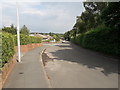
Third Avenue, Ketley Bank
Houses on Third Avenue in Ketley Bank
Image: © Richard Law
Taken: 15 Jun 2020
0.08 miles
2
A442 Queensway south of the Greyhound junction
Also known to those of us who've lived locally for a few years as The Eastern Primary (or simply the 'EP'), the road was built as part of the development of Telford New Town to serve as a fast distributor road on the eastern side of Telford.
Image: © Richard Law
Taken: 11 Nov 2023
0.10 miles
3
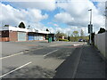
Small parade of shops on Fourth Avenue
The convenience store at the far end (just to the left of the green bus-stop shelter) was open when I walked past; all the rest appear to be closed on a Friday morning.
Image: © Richard Law
Taken: 8 Apr 2022
0.12 miles
4
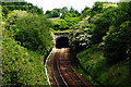
Oakengates Railway Tunnel
The Southern entrance to the Oakengates railway tunnel. Built in the 1840s to Broad Gauge dimensions although Broad Gauge track never reached this far. It is the furthest North of any structure built for Brunel's brainchild. The North end is here-- Image
Image: © Gordon Cragg
Taken: 26 May 2003
0.12 miles
5
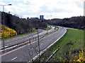
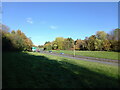
Queensway, Telford
The A442 Queensway (aka The Eastern Primary) looking South from the Greyhound Interchange towards the centre of Telford. A quiet moment for once, as the main "spine" road across Telford, it is usually fairly busy during the day.
Image: © Gordon Cragg
Taken: 26 Mar 2009
0.13 miles
6
The junction of Fourth Avenue with Sixth Avenue
Image: © Richard Law
Taken: 27 Nov 2021
0.14 miles
7
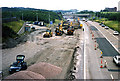
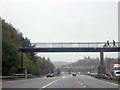
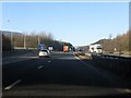
Rebuilding M54
The M54 motorway was built in the 1970's, not very well, with a concrete carriageway. For many years the driving public had to put up with the impression of driving on a railway track. It was eventually decided that it needed to be virtually re-built. The section from junction 5 westward was done in 1997, it took over five years to complete the whole job to the end of the motorway. This photo is looking East and shows the turnoff for Telford centre.Image
Image: © Gordon Cragg
Taken: Unknown
0.16 miles
8
M54 Motorway - junction 5 exit slip road, westbound
The gradient and tight curve are remarkable.
Image: © Peter Whatley
Taken: 18 Jan 2011
0.17 miles
9
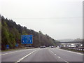
M54 Eastbound Approaching Junction 5 The A5 For Telford
Image: © Roy Hughes
Taken: 18 Apr 2012
0.18 miles