IMAGES TAKEN NEAR TO
Carmarthen Green, TELFORD, TF1 6UF
Introduction
This page details the photographs taken nearby to Carmarthen Green, TF1 6UF by members of the Geograph project.
The Geograph project started in 2005 with the aim of publishing, organising and preserving representative images for every square kilometre of Great Britain, Ireland and the Isle of Man.

There are currently over 7.5m images from over14,400 individuals and you can help contribute to the project by visiting https://www.geograph.org.uk
Image Map
Images are licensed for reuse under creativecommons.org/licenses/by-sa/2.0
Notes
- Clicking on the map will re-center to the selected point.
- The higher the marker number, the further away the image location is from the centre of the postcode.
Image Listing (11 Images Found)
Images are licensed for reuse under creativecommons.org/licenses/by-sa/2.0
Image
Details
Distance
2
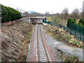
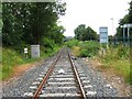
Railway Revived
This was originally part of the Wellington to Stafford line, it was closed and the track lifted in the early 1990s when the MOD depot at Donnington ceased to use rail transport. However the local authority has been instrumental in re-opening the line to link with a new freight depot at Donnington.
Beeching revenged!!
Note The Wrekin brooding in the distance.
Image: © Gordon Cragg
Taken: 28 Feb 2009
0.11 miles
6
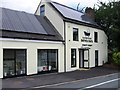
Summerhouse Bath & Taps, Telford (side view)
The place to go for bathroom and shower supplies.
Image: © Jeremy Bolwell
Taken: 24 Jul 2016
0.15 miles
7
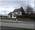
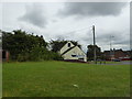
Summer House, Haybridge
former Marston's pub
Image: © al partington
Taken: 13 Apr 2006
0.17 miles
8
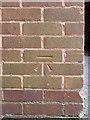
OS benchmark - Leegomery, 1 Acacia Drive
An OS cutmark on the side wall of no 1 Acacia Drive; originally levelled in 1984 at 86.264m above Ordnance Datum Newlyn.
Image: © Richard Law
Taken: 18 Oct 2015
0.20 miles
9
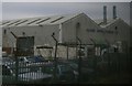
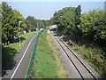
Telford Copper Cylinders Ltd., Haybridge Road Industrial Estate
Seen from the railway line.
Image: © Christopher Hilton
Taken: 9 Feb 2015
0.22 miles
10
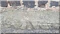
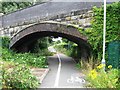
Haybridge Road Railway Bridge Benchmark
The Ordnance Survey Rivet Benchmark set into the railway bridge on Haybridge Road, Wellington, Telford. The Benchmark was first levelled in 1874. It was last levelled in 1958 with a Second Order of accuracy. The Benchmark was last verified by the OS in 1984
Image: © Anthony Rowley
Taken: 15 Jul 2022
0.22 miles