IMAGES TAKEN NEAR TO
Merlin Coppice, TELFORD, TF1 6TB
Introduction
This page details the photographs taken nearby to Merlin Coppice, TF1 6TB by members of the Geograph project.
The Geograph project started in 2005 with the aim of publishing, organising and preserving representative images for every square kilometre of Great Britain, Ireland and the Isle of Man.

There are currently over 7.5m images from over14,400 individuals and you can help contribute to the project by visiting https://www.geograph.org.uk
Image Map
Images are licensed for reuse under creativecommons.org/licenses/by-sa/2.0
Notes
- Clicking on the map will re-center to the selected point.
- The higher the marker number, the further away the image location is from the centre of the postcode.
Image Listing (9 Images Found)
Images are licensed for reuse under creativecommons.org/licenses/by-sa/2.0
Image
Details
Distance
1

The Silkin Way
The Silkin Way, long distance footpath that runs from Bratton to Ironbridge, looking South towards Leegomery.
Image: © Gordon Cragg
Taken: 25 May 2009
0.16 miles
2

New housing on Peregrine Way
Opposite Apley Woods.
Image: © Penny Mayes
Taken: 25 Oct 2021
0.21 miles


5

Visitor map at Apley Woods
Marked on the OS map as Apley Castle Park, Apley Woods seems a reasonable name. The top right corner, under the key, marked as meadows here, is actually part of the new housing estate - see Image
The map offers two suggested routes, and the paths are colour-coded for accessibility. We had no pushchairs or wheelchairs, so having figured out the less 'accessible' areas just included short flights of shallow steps, we wandered along various paths within the shorter route.
Image: © Penny Mayes
Taken: 25 Oct 2021
0.23 miles
6

Apley Woods
It looks like someone has tried to build a shelter around this rather scruffy yew tree.
Image: © Penny Mayes
Taken: 25 Oct 2021
0.24 miles
7

New housing on Peregrine Way
Part of a new housing estate opposite Apley Castle Park.
Image: © Penny Mayes
Taken: 25 Oct 2021
0.24 miles
8
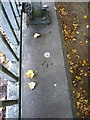
OS rivet - Leegomery, Pool Farm Drive bridge
An OS rivet on the parapet of an underpass bridge on Pool Farm Way; originally emplaced in 1984 at 80.066m above Ordnance Datum Newlyn.
Image: © Richard Law
Taken: 18 Oct 2015
0.24 miles
9
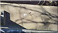
Pool Farm Avenue Subway Parapet
The Ordnance Survey Rivet Benchmark set into parapet of a subway on Pool Farm Avenue in Leegomery, Telford. The accompanying Crow's Foot is slightly damaged. The benchmark was set with a Third Order level of accuracy and was levelled & (last) verified in 1984. The reported height AODN is 80.066-metres.
Image: © Anthony Rowley
Taken: 14 Mar 2022
0.25 miles