IMAGES TAKEN NEAR TO
The Nettlefolds, TELFORD, TF1 5PF
Introduction
This page details the photographs taken nearby to The Nettlefolds, TF1 5PF by members of the Geograph project.
The Geograph project started in 2005 with the aim of publishing, organising and preserving representative images for every square kilometre of Great Britain, Ireland and the Isle of Man.

There are currently over 7.5m images from over14,400 individuals and you can help contribute to the project by visiting https://www.geograph.org.uk
Image Map
Images are licensed for reuse under creativecommons.org/licenses/by-sa/2.0
Notes
- Clicking on the map will re-center to the selected point.
- The higher the marker number, the further away the image location is from the centre of the postcode.
Image Listing (21 Images Found)
Images are licensed for reuse under creativecommons.org/licenses/by-sa/2.0
Image
Details
Distance
1
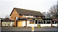
The Bush, Hadley, Telford
The Bush public house, empty and awaiting demolition in 2003. The site has now been cleared and is awaiting development.
Image: © Gordon Cragg
Taken: Unknown
0.16 miles
3
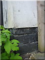
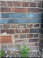
OS benchmark - Hadley, 60 Castle Street
Almost completely obscured by the rendering on the front wall, apart from the tail of one of the arrows, there is nonetheless an OS cutmark on the front of this house which was originally levelled in 1958 at 82.452m above Ordnance Datum Newlyn.
Image: © Richard Law
Taken: 16 Jul 2016
0.18 miles
4
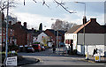
High Street, Hadley, Telford
Entrance to High St. Hadley, Telford.
Image: © Gordon Cragg
Taken: 19 Feb 2010
0.18 miles
5
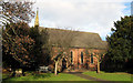
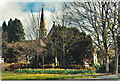
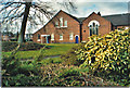
Holy Trinity , Hadley
Holy Trinity, the parish church of Hadley, Telford.
Image: © Gordon Cragg
Taken: 19 Feb 2010
0.18 miles
6
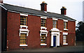
Former Barclays Bank, Hadley
One time this attractive building was a branch of Barclays Bank. Now in use as offices.
Image: © Gordon Cragg
Taken: 21 Jan 2003
0.18 miles
7
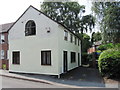
Old Toll House, Hadley
Toll House in the parish of Hadley, 59 High Street, Hadley.
Shropshire HER.
HER Number (PRN): 32236 https://www.heritagegateway.org.uk/Gateway/Results_Single.aspx?uid=MSA35048&resourceID=1015
Surveyed
Milestone Society National ID: SA.HAD
Image: © Milestone Society
Taken: Unknown
0.18 miles
8
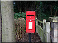
"ERII" Post Box, Hadley
An "ERII" post box on post near parish church, Waterloo Road, Hadley, Telford.
Image: © Gordon Cragg
Taken: 19 Feb 2010
0.19 miles
9
OS benchmark - Hadley, Methodist Church
An OS cutmark on the east wall (around to the left of the frontage in Image) which was originally levelled in 1958 at 86.405m above Ordnance Datum Newlyn.
Image: © Richard Law
Taken: 16 Jul 2016
0.21 miles
10
Hadley Methodist Church
The congregation celebrated 300 years since the birth of Charles Wesley by singing his hymns in July 2007.
Image: © Carol Walker
Taken: Unknown
0.21 miles