IMAGES TAKEN NEAR TO
Beddall Way, TELFORD, TF1 5FN
Introduction
This page details the photographs taken nearby to Beddall Way, TF1 5FN by members of the Geograph project.
The Geograph project started in 2005 with the aim of publishing, organising and preserving representative images for every square kilometre of Great Britain, Ireland and the Isle of Man.

There are currently over 7.5m images from over14,400 individuals and you can help contribute to the project by visiting https://www.geograph.org.uk
Image Map (Loading...)


Getting Data...Please wait
Leaflet Map data © OpenStreetMap
Images are licensed for reuse under creativecommons.org/licenses/by-sa/2.0
Notes
- Clicking on the map will re-center to the selected point.
- The higher the marker number, the further away the image location is from the centre of the postcode.
Image Listing (22 Images Found)
Images are licensed for reuse under creativecommons.org/licenses/by-sa/2.0
Image
Details
Distance
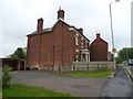
1
Hadley Millennium Village
Hadley Millennium Village is to be built on this site north of the old A5 (B5061) in good time for the next millennium. Glen Cottages, at the centre of the site, are about to be surrounded by the new build.
Image: © Mike White
Taken: 26 May 2008
0.12 miles
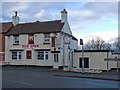
2
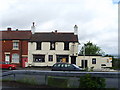
The Unicorn, Ketley
Right on the grid line lies this pub looking a little worse for wear.
Image: © A Holmes
Taken: 1 Jul 2007
0.16 miles
3
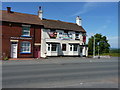
The Mauchak Indian Restaurant
Formerly the Pudding Inn on the old A5 at Ketley, at which time it had signage on the wall saying "Good food, strange staff" or something very similar. That always made me smile.
Image: © Richard Law
Taken: 20 Jun 2010
0.17 miles
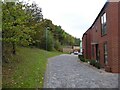
4

Oak Trees Avenue, Ketley
Oak Trees Avenue is on the southern edge of the development and consists of four short side streets. They are lined with a mix of detached, semi-detached and terraced houses, in varying designs, colours and materials.
The streets are paved with various colours of paviours.
Royal Mail says Ketley is the correct address, rather than Hadley, as suggested by Mike White in his 2008 shot of part of the site for this development Image Five of the semi-detached pairs in Mike's photo have been refurbished and retained. The part of the development shown here is out of shot to the right in his pic.
Image: © Penny Mayes
Taken: 24 Oct 2021
0.17 miles
5

Oak Trees Avenue, Ketley
Oak Trees Avenue is on the southern edge of the development and consists of four short side streets. They are lined with a mix of detached, semi-detached and terraced houses, in varying designs and materials. The streets are paved with various colours of paviours.
The numbers set in the parking places may relate to plot numbers, they certainly don't match the house numbers.
Royal Mail says Ketley is the correct address, rather than Hadley, as suggested by Mike White in his 2008 shot of part of the site for this development Image Five of the semi-detached pairs in Mike's photo have been refurbished and retained.
The part of the development shown here is out of shot to the right in his pic.
Image: © Penny Mayes
Taken: 24 Oct 2021
0.17 miles
6

Oak Trees Avenue, Ketley
Oak Trees Avenue is on the southern edge of the development and consists of four short side streets. They are lined with a mix of detached, semi-detached and terraced houses, in varying designs, colours and materials. This streetlet has mostly detached houses with one three-house-terrace, they are all brick-clad.
The streets are paved with various colours of paviours.
Royal Mail says Ketley is the correct address, rather than Hadley, as suggested by Mike White in his 2008 shot of part of the site for this development Image Five of the semi-detached pairs in Mike's photo have been refurbished and retained.
The part of the development shown here is out of shot to the right in his pic.
Image: © Penny Mayes
Taken: 24 Oct 2021
0.17 miles
7

Oak Trees Avenue, Ketley
Oak Trees Avenue is on the southern edge of the development and consists of four short side streets. They are lined with a mix of detached, semi-detached and terraced houses, in varying designs and materials. The streets are paved with various colours of paviours.
Royal Mail says Ketley is the correct address, rather than Hadley, as suggested by Mike White in his 2008 shot of part of the site for this development Image Five of the semi-detached pairs in Mike's photo have been refurbished and retained.
The part of the development shown here is out of shot to the right in his pic. The bank which has been cut into to create some of the gardens here, led up to the old lane shown on the right in Mike's photo.
Image: © Penny Mayes
Taken: 24 Oct 2021
0.18 miles
8
The Unicorn, Ketley
It used to look like this: Image, but now it's an Indian restaurant. It is named on the 1889 map, and endured a brief spell as 'The Pudding Inn', part of Mad O'Rourke's Black Country pub chain. Then it became the Unicorn again, but has now found a new role and name. Very steep car park at the back, I remember.
Image: © Mike White
Taken: 14 Jan 2009
0.18 miles
9
Oak Trees Avenue, Ketley
Oak Trees Avenue is on the southern edge of the development and consists of four short side streets, two of which are linked by this cross street (see https://www.geograph.org.uk/photo/7075809 for reciprocal view). They are lined with a mix of detached, semi-detached and terraced houses, in varying designs, colours and materials.
The streets are paved with various colours of paviours.
Royal Mail says Ketley is the correct address, rather than Hadley, as suggested by Mike White in his 2008 shot of part of the site for this development Image Five of the semi-detached pairs in Mike's photo have been refurbished and retained.
The part of the development shown here is out of shot to the right in his pic.
Image: © Penny Mayes
Taken: 24 Oct 2021
0.18 miles