
IMAGES TAKEN NEAR TO
Shepherds Lane, TELFORD, TF1 5EH
Introduction
This page details the photographs taken nearby to Shepherds Lane, TF1 5EH by members of the Geograph project.
The Geograph project started in 2005 with the aim of publishing, organising and preserving representative images for every square kilometre of Great Britain, Ireland and the Isle of Man.

There are currently over 7.5m images from over14,400 individuals and you can help contribute to the project by visiting https://www.geograph.org.uk
Image Map
Images are licensed for reuse under creativecommons.org/licenses/by-sa/2.0
Notes
- Clicking on the map will re-center to the selected point.
- The higher the marker number, the further away the image location is from the centre of the postcode.
Image Listing (37 Images Found)
Images are licensed for reuse under creativecommons.org/licenses/by-sa/2.0
Image
Details
Distance
1
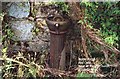
Water Pump near St. Mary's Church Red Lake Telford
Before the days of universal piped water each little neighbourhood had a public water pump available for the local people to use.
Image: © Gordon Cragg
Taken: Unknown
0.00 miles
2
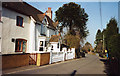
Shepherds Lane, Red Lake
Looking North along Shepherds Lane toward Red Lees, Ketley.
Image: © Gordon Cragg
Taken: Unknown
0.01 miles
3
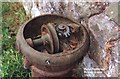
Water Pump near St. Mary's Church Red Lake Telford
A close up of the mechanism for the pump.
Image: © Gordon Cragg
Taken: Unknown
0.01 miles
4
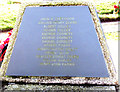
War Memorial St Mary's Church Red Lake, Listings C to H
Names from C to H on the War Memorial at St Mary's Church, Red Lake, Telford. Image
Image: © Gordon Cragg
Taken: 20 Feb 2009
0.03 miles
5
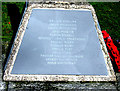
War Memorial St Mary's Church Red Lake, Listings P to W
Names from P to W on the War Memorial at St Mary's Church, Red Lake, Telford. Image
Image: © Gordon Cragg
Taken: 20 Feb 2009
0.03 miles
6
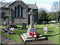
The War Memorial, St Mary's, Red Lake, Ketley
Here is an updated photograph of this War Memorial, the names have been reinscribed on slate insets over the original carvings which were badly worn.
This was the original picture submitted - Image
Listing of names on these photos -
Image
Image
Image
Image: © Gordon Cragg
Taken: 20 Feb 2009
0.03 miles
7
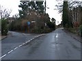
Old road junction, Red Lake
According to the signpost, the road from Ketley, Oakengates and Wellington goes straight on for Old Park and Dawley; fork left for Ketley Bank. Not any more. The Mossey Green Road dual carriageway has truncated the road to Ketley bank, though Old Park and Dawley can still be reached--via Mossey Green Road.
The signpost can be seen at Image The circle at the top says where we are: Red Lake.
Image: © Mike White
Taken: 14 Jan 2009
0.04 miles
8
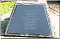
War Memorial St Mary's Church Red Lake, Listings H to M
Names from H to M on the War Memorial at St Mary's Church, Red Lake, Telford. Image
Image: © Gordon Cragg
Taken: 20 Feb 2009
0.04 miles
9
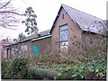
St Mary's Church Hall, Red Lake
Another view of Image The old school building can be seen more clearly. Slates were falling off its roof and more seem ready to fall.
Image: © Mike White
Taken: 14 Jan 2009
0.04 miles
10
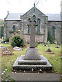
War Memorial St Mary's Church Red Lake
If you would like details of the names on this memorial please email. http://NeTelford.fotopic.net . The names on the memorial have since been re-inscribed on slate panels, see updated photograph Image
Image: © Gordon Cragg
Taken: 6 Nov 2003
0.04 miles