IMAGES TAKEN NEAR TO
College Lane, TELFORD, TF1 3DH

Introduction

This page details the photographs taken nearby to College Lane, TF1 3DH by members of the Geograph project.

The Geograph project started in 2005 with the aim of publishing, organising and preserving representative images for every square kilometre of Great Britain, Ireland and the Isle of Man.

There are currently over 7.5m images from over14,400 individuals and you can help contribute to the project by visiting https://www.geograph.org.uk

Image Map (Loading...)

MarkerMarker

Images are licensed for reuse under creativecommons.org/licenses/by-sa/2.0
Notes
  • Clicking on the map will re-center to the selected point.
  • The higher the marker number, the further away the image location is from the centre of the postcode.

Image Listing (6 Images Found)

Images are licensed for reuse under creativecommons.org/licenses/by-sa/2.0
Image
Details
Distance
1
Footbridge over the A5223
Image: © Richard Law Taken: 4 Aug 2012
0.09 miles
2
Footbridge linking Wellington and Leegomery
A bridge over the A5223, Whitchurch Road which runs through a wooded cutting (reducing traffic noise to local estates)
Image: © David Smith Taken: 30 Sep 2016
0.10 miles
3
Apley residence
Buildings in a quiet cul-de-sac near Apley Castle
Image: © Andy and Hilary Taken: 17 Apr 2005
0.15 miles
4
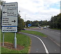
Locations near Wellington Shropshire
The sign is alongside Apley Avenue on the approach to Apley Roundabout. Why are no distances shown?
Image: © Jaggery Taken: 10 Oct 2013
0.20 miles
5
Kingfisher Way, Apley, Wellington
Viewed across Grainger Drive.
Image: © Jaggery Taken: 10 Oct 2013
0.22 miles
6
Western boundary of Apley, Wellington
The boundary sign alongside Grainger Drive shows that Apley is part of Hadley and Leegomery Parish.
Image: © Jaggery Taken: 10 Oct 2013
0.22 miles