IMAGES TAKEN NEAR TO
Alverley Close, TELFORD, TF1 3AT
Introduction
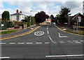
This page details the photographs taken nearby to Alverley Close, TF1 3AT by members of the Geograph project.
The Geograph project started in 2005 with the aim of publishing, organising and preserving representative images for every square kilometre of Great Britain, Ireland and the Isle of Man.

There are currently over 7.5m images from over14,400 individuals and you can help contribute to the project by visiting https://www.geograph.org.uk
Image Map
Images are licensed for reuse under creativecommons.org/licenses/by-sa/2.0
Notes
- Clicking on the map will re-center to the selected point.
- The higher the marker number, the further away the image location is from the centre of the postcode.
Image Listing (209 Images Found)
Images are licensed for reuse under creativecommons.org/licenses/by-sa/2.0
Image
Details
Distance
1
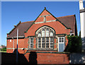
Wellington - former school on Constitution Hill
Image: © Dave Bevis
Taken: 22 Sep 2012
0.04 miles
2
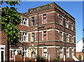
Wellington - Roslyn House
Part of Wrekin College.
Image: © Dave Bevis
Taken: 22 Sep 2012
0.05 miles
3
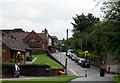
Constitution Hill, Wellington
Looking East up Constitution Hill, Wellington.
Image: © Gordon Cragg
Taken: 19 May 2009
0.05 miles
4

Union Free Church, Wellington
Viewed across Constitution Hill. The name sign shows Union Free Church (Baptist and United Reformed). The date on the foundation stones is September 1st 1899.
Image: © Jaggery
Taken: 10 Oct 2013
0.06 miles
5

Constitution Hill Wellington
Viewed across King Street.
Image: © Jaggery
Taken: 10 Oct 2013
0.06 miles
6
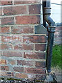
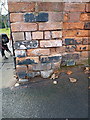
OS benchmark - Wellington, 33 Albert Road
An OS cutmark in the bricks of no 33 Albert Road, originally levelled at 102.46m above Ordnance Datum Newlyn.
Image: © Richard Law
Taken: 8 Dec 2013
0.06 miles
7
Albert Road Wellington
Looking east along Albert Road from King Street.
Image: © Jaggery
Taken: 10 Oct 2013
0.06 miles
8

Denise's Salon in Wellington
The hairdressing salon at 46A King Street is opposite Constitution Hill. http://www.geograph.org.uk/photo/3696900
Image: © Jaggery
Taken: 10 Oct 2013
0.07 miles
9
OS benchmark - Wellington, entrance to church on King Street
A rather poorly preserved OS cutmark in the brick pillar at the side of the entrance to the All Saints church; originally levelled at 97.363m above Ordnance Datum Newlyn.
Image: © Richard Law
Taken: 8 Dec 2013
0.09 miles
10
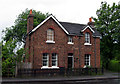
Former Station House
The one time station-master's house at Wellington. Now private property.
Image: © Gordon Cragg
Taken: 19 May 2009
0.09 miles