IMAGES TAKEN NEAR TO
Corvelands, MUCH WENLOCK, TF13 6QU
Introduction
This page details the photographs taken nearby to Corvelands, TF13 6QU by members of the Geograph project.
The Geograph project started in 2005 with the aim of publishing, organising and preserving representative images for every square kilometre of Great Britain, Ireland and the Isle of Man.

There are currently over 7.5m images from over14,400 individuals and you can help contribute to the project by visiting https://www.geograph.org.uk
Image Map
Images are licensed for reuse under creativecommons.org/licenses/by-sa/2.0
Notes
- Clicking on the map will re-center to the selected point.
- The higher the marker number, the further away the image location is from the centre of the postcode.
Image Listing (14 Images Found)
Images are licensed for reuse under creativecommons.org/licenses/by-sa/2.0
Image
Details
Distance
1
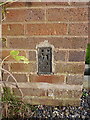
OS flush bracket - Weston
Flush Bracket G2189 installed on the side of the porch of 'Corvelands', one of the houses in Weston. It was originally levelled in 1952, during the Third Geodetic Levelling of England & Wales, at 181.038m above Ordnance Datum Newlyn.
Image: © Richard Law
Taken: 19 Nov 2017
0.02 miles
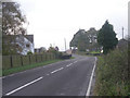
2
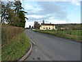
The B4368 towards Morville
The road seen as it passes through Weston hamlet.
Image: © Richard Law
Taken: 19 Nov 2017
0.02 miles
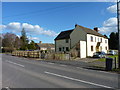
3
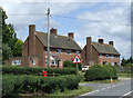
Housing at Weston, Shropshire
These appear to be council built semi-detached residences from the 1960s (?)
Image: © Roger Kidd
Taken: 7 Jul 2007
0.02 miles
4
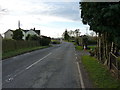
B4368 passing through Weston
Something of a racetrack, the B4368 takes traffic from Morville to Shipton via a series of small settlements and farm entrances.
Image: © Richard Law
Taken: 19 Nov 2017
0.03 miles
6
Roadside houses
In the hamlet of Weston.
Image: © James Allan
Taken: 2 Apr 2016
0.06 miles
7
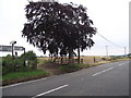
Netchwood Junction
A rather attractive Copper Beech tree stands close to the B4368.
The footpath behind links up to Corve Barn farm.
Image: © Anthony Vosper
Taken: 27 Jul 2011
0.07 miles
8

Ordnance Survey Cut Mark
This OS cut mark can be found on the roadside barn. It marks a point 178.687m above mean sea level.
Image: © Adrian Dust
Taken: 13 Mar 2017
0.09 miles
9
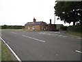
Pay up
A former Toll House on the B4368.
Image: © Anthony Vosper
Taken: 27 Jul 2011
0.10 miles
10
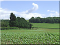
Crop Field, Weston, Shropshire
This crop of maize is recovering from continuous recent heavy rain, hopefully with only limited damage.
Image: © Roger Kidd
Taken: 7 Jul 2007
0.18 miles