IMAGES TAKEN NEAR TO
MUCH WENLOCK, TF13 6PS
Introduction
This page details the photographs taken nearby to TF13 6PS by members of the Geograph project.
The Geograph project started in 2005 with the aim of publishing, organising and preserving representative images for every square kilometre of Great Britain, Ireland and the Isle of Man.

There are currently over 7.5m images from over14,400 individuals and you can help contribute to the project by visiting https://www.geograph.org.uk
Image Map
Images are licensed for reuse under creativecommons.org/licenses/by-sa/2.0
Notes
- Clicking on the map will re-center to the selected point.
- The higher the marker number, the further away the image location is from the centre of the postcode.
Image Listing (13 Images Found)
Images are licensed for reuse under creativecommons.org/licenses/by-sa/2.0
Image
Details
Distance
4
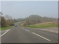
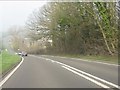
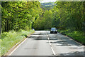
Crossroads on the A458 near Beggarhill Brook Farm
Image: © Peter Whatley
Taken: 23 Mar 2012
0.09 miles
6
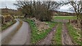
Not as muddy as you might have thought
At least, this bit wasn't as muddy as suspected in Image - but the next section south looked like a quagmire, so we turned around.
Image: © Richard Law
Taken: 7 Oct 2012
0.12 miles
10
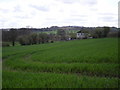
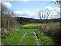
Across the field to Atterley Cottage
The summit of Brown Clee Hill can be seen on the distant horizon.
Image: © Row17
Taken: 23 Apr 2008
0.16 miles