IMAGES TAKEN NEAR TO
Easthope Wood, MUCH WENLOCK, TF13 6DL
Introduction
This page details the photographs taken nearby to TF13 6DL by members of the Geograph project.
The Geograph project started in 2005 with the aim of publishing, organising and preserving representative images for every square kilometre of Great Britain, Ireland and the Isle of Man.

There are currently over 7.5m images from over14,400 individuals and you can help contribute to the project by visiting https://www.geograph.org.uk
Image Map
Images are licensed for reuse under creativecommons.org/licenses/by-sa/2.0
Notes
- Clicking on the map will re-center to the selected point.
- The higher the marker number, the further away the image location is from the centre of the postcode.
Image Listing (21 Images Found)
Images are licensed for reuse under creativecommons.org/licenses/by-sa/2.0
Image
Details
Distance
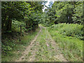
1
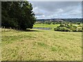
View west from Wenlock Edge
Looking downhill along the footpath (by the tree line) towards the agricultural pond.
Image: © TCExplorer
Taken: 23 Jul 2023
0.12 miles
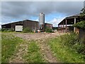
2
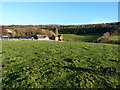
Easthope Wood Farm
A view of the farm from the west
Image: © Richard Law
Taken: 13 Nov 2010
0.12 miles
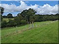
3
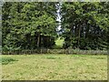
Gate in the trees
Access between the two fields.
Image: © TCExplorer
Taken: 23 Jul 2023
0.14 miles
6
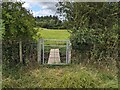
Board bridge and gate on public footpath
Image: © TCExplorer
Taken: 23 Jul 2023
0.20 miles
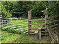
8
Public footpath gate
It's ever so slightly to the north of where it's marked on OS 1:25k mapping.
Image: © TCExplorer
Taken: 23 Jul 2023
0.21 miles
10
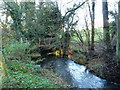
Footbridge over the Hughley Brook
Just east of Image, this footbridge takes the footpath from the bottom of Wenlock Edge towards Church Preen.
Image: © Richard Law
Taken: 13 Nov 2010
0.23 miles