IMAGES TAKEN NEAR TO
Guest Road, BROSELEY, TF12 5RZ
Introduction
This page details the photographs taken nearby to Guest Road, TF12 5RZ by members of the Geograph project.
The Geograph project started in 2005 with the aim of publishing, organising and preserving representative images for every square kilometre of Great Britain, Ireland and the Isle of Man.

There are currently over 7.5m images from over14,400 individuals and you can help contribute to the project by visiting https://www.geograph.org.uk
Image Map
Images are licensed for reuse under creativecommons.org/licenses/by-sa/2.0
Notes
- Clicking on the map will re-center to the selected point.
- The higher the marker number, the further away the image location is from the centre of the postcode.
Image Listing (13 Images Found)
Images are licensed for reuse under creativecommons.org/licenses/by-sa/2.0
Image
Details
Distance
1
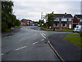
The junction of Brookes Road and Guest Road, Broseley
A street junction in this 1970s estate on the east side of Broseley
Image: © Richard Law
Taken: 24 Aug 2010
0.04 miles
2
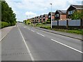
Coalport Road
Houses built in the 1970s on Coalport Road in Broseley.
Image: © Philip Halling
Taken: 2 Jun 2021
0.15 miles
3
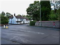
The King and Thai
A clever name for a Thai restaurant, if ever there was one. They moved here from a site down beside the Ironbridge a few years ago, moving into the former Forester's Arms pub.
The postbox in the wall on the right is TF12 36, an Elizabeth II wallbox by Carron & Co, of Falkirk.
Image: © Richard Law
Taken: 24 Aug 2010
0.15 miles
4
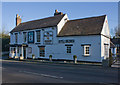
Forester's Arms, Broseley
And 'The King and Thai' restaurant. Also clever to make the phone number big enough to read as you drive by. I've enjoyed a meal there.
Image: © Mike White
Taken: 30 Jan 2010
0.16 miles
5
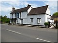
Forester's Arms, Broseley
The Forrester's Arms in Broseley appears to be closed at present, not sure if it is a temporary COVID-19 measure or a more permanent closure. Here it is pictured in happier days Image
Image: © Philip Halling
Taken: 2 Jun 2021
0.16 miles
6
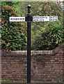
Old Direction Sign - Signpost by the B4373, Avenue Road, Broseley Parish
Ball finial - 3 arms; by the B4373, in parish of Broseley (Bridgnorth District), South East of village at junction with the B4375.
Surveyed
Milestone Society National ID: SA_SJ6701
Image: © Milestone Society
Taken: Unknown
0.17 miles
7
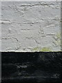
OS benchmark - Broseley, former Forester's Arms pub
Time has not been kind to these rather poorly-kept remains of the OS benchmark, which are now just about visible on the gable wall of the restaurant seen in Image It was originally levelled in 1958 at 142.231m above Ordnance Datum Newlyn.
Image: © Richard Law
Taken: 31 Jan 2016
0.17 miles
8
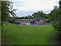
The John Wilkinson Primary School, Coalport Road
Image: © Richard Law
Taken: 24 Aug 2010
0.18 miles
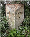
9
Milepost, Broseley
15 miles to Shrewsbury; 6 to Bridgnorth.
Image: © Mike White
Taken: 30 Jan 2010
0.19 miles
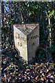
10
Old Milepost by the B4373, Avenue Road, Broseley
Cast iron post by the B4373, in parish of Broseley (Bridgnorth District), Avenue Road, Broseley; 80m South of Forester's Arms, in hedge, on West side of road. Erected by the Wenlock turnpike trust in the 19th century.
Inscription reads:-
: SALOP / 15 : : IRON BRIDGE / 2 / {motif} : : B. NORTH / 6 :
Shropshire HER.
HER Number (PRN): 21111 https://www.heritagegateway.org.uk/Gateway/Results_Single.aspx?uid=MSA23684&resourceID=1015
Milestone Society National ID: SA_IRBN02
Image: © Mike Faherty
Taken: 14 Mar 2008
0.19 miles