IMAGES TAKEN NEAR TO
Linley Green, BROSELEY, TF12 5JX
Introduction
This page details the photographs taken nearby to Linley Green, TF12 5JX by members of the Geograph project.
The Geograph project started in 2005 with the aim of publishing, organising and preserving representative images for every square kilometre of Great Britain, Ireland and the Isle of Man.

There are currently over 7.5m images from over14,400 individuals and you can help contribute to the project by visiting https://www.geograph.org.uk
Image Map
Images are licensed for reuse under creativecommons.org/licenses/by-sa/2.0
Notes
- Clicking on the map will re-center to the selected point.
- The higher the marker number, the further away the image location is from the centre of the postcode.
Image Listing (15 Images Found)
Images are licensed for reuse under creativecommons.org/licenses/by-sa/2.0
Image
Details
Distance
1
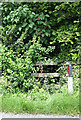
Public Footpath, I think! Linleygreen, Shropshire
This was dire! The next 50 metres are narrow, overgrown, and all but impassable.
Image: © Roger Kidd
Taken: 3 Jun 2007
0.05 miles
3
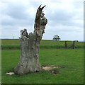
Dead Oak Tree, Linleygreen, Shropshire
The public footpath across the stile enters a field that, considering the wealth of wild flowers, and the stout thistles and occasional bramble, may have been "set-aside" for more than a year. From here on, the footpath is undefined on the ground - use a compass in the fog!!
Image: © Roger Kidd
Taken: 3 Jun 2007
0.12 miles
5
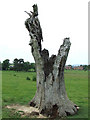
Dead Oak Tree, Linleygreen, Shropshire
To gain access to this ancient relic walkers will need to negotiate 80 metres of overgrown and narrow fenced public footpath from the B4373.
Image: © Roger Kidd
Taken: 3 Jun 2007
0.12 miles
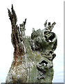
6
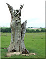
Dead Oak Tree, Linleygreen, Shropshire
The defiant wing-flapping top of this sculptured relic brings to mind the most desolate wastelands of Tolkien's Ring.
Image: © Roger Kidd
Taken: 3 Jun 2007
0.12 miles
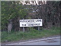
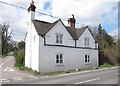
8
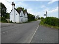
House on a road junction
House on the B4373 on junction with the road to Willey.
Image: © Philip Halling
Taken: 2 Jun 2021
0.16 miles
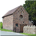
9
Old Toll House, Linley Green
Toll House in the parish of Barrow, in Linley Green, at the junction of the B4373 and Scots Lane.
Shropshire HER.
HER Number (PRN): 33121 https://www.heritagegateway.org.uk/Gateway/Results_Single.aspx?uid=MSA35968&resourceID=1015
Surveyed
Milestone Society National ID: SA.BAR03
Image: © Milestone Society
Taken: Unknown
0.17 miles
10
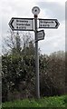
Old Direction Sign - Signpost by the B4373, Barrow Parish
Disc finial - 3 Worboys arms; by the B4373, in parish of Barrow (Bridgnorth District), crossroad junction of Bridgnorth Road and Scots Lane, on verge, against hedge.
Surveyed
Milestone Society National ID: SA_SO6899
Image: © Milestone Society
Taken: Unknown
0.17 miles