
IMAGES TAKEN NEAR TO
Avenue Road, BROSELEY, TF12 5JF
Introduction
This page details the photographs taken nearby to Avenue Road, TF12 5JF by members of the Geograph project.
The Geograph project started in 2005 with the aim of publishing, organising and preserving representative images for every square kilometre of Great Britain, Ireland and the Isle of Man.

There are currently over 7.5m images from over14,400 individuals and you can help contribute to the project by visiting https://www.geograph.org.uk
Image Map
Images are licensed for reuse under creativecommons.org/licenses/by-sa/2.0
Notes
- Clicking on the map will re-center to the selected point.
- The higher the marker number, the further away the image location is from the centre of the postcode.
Image Listing (36 Images Found)
Images are licensed for reuse under creativecommons.org/licenses/by-sa/2.0
Image
Details
Distance
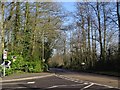
2
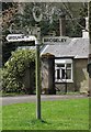
Old Direction Sign - Signpost by the B4373, Broseley
Annulus finial - 3 arms; Shropshire CC modern halo by the B4373, in parish of Broseley (Bridgnorth District), Broseley.
Surveyed
Milestone Society National ID: SA_SJ6701A
Image: © Milestone Society
Taken: Unknown
0.06 miles
3
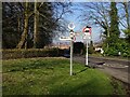
B4373 signpost, Broseley
Other than Willey's driveway, all three roads at this junction are the B4373. Avenue Road meets Bridgnorth road just south of Broseley.
Image: © Richard Webb
Taken: 15 Feb 2019
0.06 miles
4
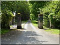
Entrance to Willey Estate
Gate piers at the entrance to Willey Estate beside the Broseley Lodge.
Image: © Philip Halling
Taken: 2 Jun 2021
0.07 miles
5
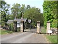
Lodge to Willey Park
The private drive links Willey Hall to the Ironbridge road on the outskirts of Broseley.
Image: © John M
Taken: 28 Apr 2007
0.08 miles
6
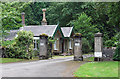
Lodge and gates near Broseley
Belonging to Willey Hall which lies more than 1.5 miles away - the drive passes under the B4376. Built c1828 with very decorative bargeboards and extravagant chimney stacks. Grade II listed.
Image: © Stephen Richards
Taken: Unknown
0.08 miles
7
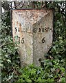
Old Milepost by the B4373, Avenue Road, Broseley
Cast iron post by the B4373, in parish of Broseley (Bridgnorth District), Avenue Road, Broseley; 80m South of Forester's Arms, in hedge, on West side of road. Erected by the Wenlock turnpike trust in the 19th century.
Inscription reads:-
: SALOP / 15 : : IRON BRIDGE / 2 / {motif} : : B. NORTH / 6 :
Shropshire HER.
HER Number (PRN): 21111 https://www.heritagegateway.org.uk/Gateway/Results_Single.aspx?uid=MSA23684&resourceID=1015
Milestone Society National ID: SA_IRBN02
Image: © Mike Faherty
Taken: 14 Mar 2008
0.09 miles
8
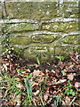
OS benchmark - Broseley, Bridgnorth Road
A clear OS cutmark on a roadside wall; originally levelled at 151.708m above Ordnance Datum Newlyn in the late 1950s or early 1960s.
Image: © Richard Law
Taken: 31 Jan 2016
0.09 miles
9
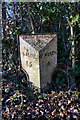
Milepost, Broseley
15 miles to Shrewsbury; 6 to Bridgnorth.
Image: © Mike White
Taken: 30 Jan 2010
0.11 miles
10
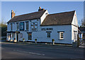
Forester's Arms, Broseley
And 'The King and Thai' restaurant. Also clever to make the phone number big enough to read as you drive by. I've enjoyed a meal there.
Image: © Mike White
Taken: 30 Jan 2010
0.13 miles