IMAGES TAKEN NEAR TO
Pound Lane, BROSELEY, TF12 5AU
Introduction
This page details the photographs taken nearby to Pound Lane, TF12 5AU by members of the Geograph project.
The Geograph project started in 2005 with the aim of publishing, organising and preserving representative images for every square kilometre of Great Britain, Ireland and the Isle of Man.

There are currently over 7.5m images from over14,400 individuals and you can help contribute to the project by visiting https://www.geograph.org.uk
Image Map
Images are licensed for reuse under creativecommons.org/licenses/by-sa/2.0
Notes
- Clicking on the map will re-center to the selected point.
- The higher the marker number, the further away the image location is from the centre of the postcode.
Image Listing (4 Images Found)
Images are licensed for reuse under creativecommons.org/licenses/by-sa/2.0
Image
Details
Distance
1
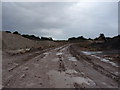
Dumper track and quarry machinery
Part of the workings in the opencast clay pit - the machine appears to be a grader or screen to separate stone into different sizes.
Image: © Richard Law
Taken: 24 Aug 2010
0.15 miles
2
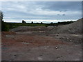
Opencast clay workings at Broseley
A dull evening in the clay pit just north of Bradley's Coppice
Image: © Richard Law
Taken: 24 Aug 2010
0.18 miles
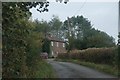
4

Inett
The 18th century house near the end of Caughley Road Broseley.
Image: © Row17
Taken: 7 Oct 2007
0.23 miles