IMAGES TAKEN NEAR TO
Chapel Lane, TELFORD, TF1 1SS
Introduction
This page details the photographs taken nearby to Chapel Lane, TF1 1SS by members of the Geograph project.
The Geograph project started in 2005 with the aim of publishing, organising and preserving representative images for every square kilometre of Great Britain, Ireland and the Isle of Man.

There are currently over 7.5m images from over14,400 individuals and you can help contribute to the project by visiting https://www.geograph.org.uk
Image Map (Loading...)


Getting Data...Please wait
Leaflet Map data © OpenStreetMap
Images are licensed for reuse under creativecommons.org/licenses/by-sa/2.0
Notes
- Clicking on the map will re-center to the selected point.
- The higher the marker number, the further away the image location is from the centre of the postcode.
Image Listing (272 Images Found)
Images are licensed for reuse under creativecommons.org/licenses/by-sa/2.0
Image
Details
Distance
1
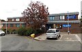
Wellington Medical Practice and Wellington Pharmacy
Set back from the east side of Victoria Road in Wellington town centre.
Image: © Jaggery
Taken: 10 Oct 2013
0.01 miles
2
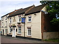
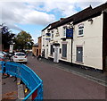
The Three Crowns, High Street
A pub in the High Street, Wellington.
Image: © Richard Law
Taken: 16 May 2009
0.02 miles
3
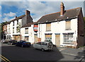
Boarded-up properties in High Street Wellington
In contrast to the main shopping streets of Wellington, in and near New Street, High Street to the east had a very run-down appearance in October 2013, with many premises boarded up.
Some others that were not boarded up displayed For Sale boards.
Image: © Jaggery
Taken: 10 Oct 2013
0.02 miles
4
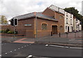
Harry Edwards & Sons, Wellington
Funeral directors on the corner of Victoria Road and High Street.
Image: © Jaggery
Taken: 10 Oct 2013
0.03 miles
5
The Three Crowns for sale in Wellington
Metal sheets protect the door and ground floor windows of the closed pub at the western end of High Street. This is one of several derelict former businesses in High Street Wellington. Located east of the main shopping area (which is in and around New Street), High Street in October 2013 was a quiet and depressing backwater.
Image: © Jaggery
Taken: 10 Oct 2013
0.03 miles
6
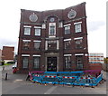
Former Chad Valley Wrekin Toy Works in Wellington
Looking here like a cardboard cutout, this is the High Street side of a substantial building http://www.geograph.org.uk/photo/3702006 extending along St John Street, built as a Wesleyan Methodist chapel in 1836, though the curved frontage seen here was absent until the early 1920s. A Sunday School extension was added to accommodate more than 400 children who attended regularly.
As Victorian Methodism become more popular, a larger church was built elsewhere in 1882 whereupon this building was renamed Central Hall, where groups such as Bible Reading and the YMCA met.
From 1916-1975, the building was a Chad Valley factory which made many soft toys, including the Smurfs, Flooks and Harry Corbett's glove puppets Sooty, Sweep and Soo.
Now (October 2013) in use as flats.
Image: © Jaggery
Taken: 10 Oct 2013
0.03 miles
7
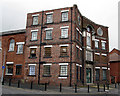
Old Chad Valley Toy Factory, Wellington
The old Chad Valley Toy Factory in High St. Wellington. Still has the Chad Valley logo on the wall above the centre windows. Has now been converted into apartments.
Image: © Gordon Cragg
Taken: 7 Jul 2009
0.04 miles
8

Old Bus Station, Wellington
The old bus station at Wellington is now being converted into a car-park. Image]
Image: © Gordon Cragg
Taken: 3 Jul 2009
0.04 miles
9
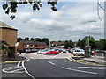
New Car Park, Wellington
Following the relocation of the bus station, to a site nearer the railway station, the former site Image has been laid out as a car park. 18 August 2009.
Image: © Gordon Cragg
Taken: 18 Aug 2009
0.04 miles
10
Izzy's, Wellington
Town centre cafe and restaurant at 71 New Street.
Former occupiers of the building include Cafe Del Manso and Copper Kettle.
Image: © Jaggery
Taken: 10 Oct 2013
0.05 miles