IMAGES TAKEN NEAR TO
Green Man Close, TELFORD, TF1 1SP
Introduction
This page details the photographs taken nearby to Green Man Close, TF1 1SP by members of the Geograph project.
The Geograph project started in 2005 with the aim of publishing, organising and preserving representative images for every square kilometre of Great Britain, Ireland and the Isle of Man.

There are currently over 7.5m images from over14,400 individuals and you can help contribute to the project by visiting https://www.geograph.org.uk
Image Map (Loading...)


Getting Data...Please wait
Leaflet Map data © OpenStreetMap
Images are licensed for reuse under creativecommons.org/licenses/by-sa/2.0
Notes
- Clicking on the map will re-center to the selected point.
- The higher the marker number, the further away the image location is from the centre of the postcode.
Image Listing (60 Images Found)
Images are licensed for reuse under creativecommons.org/licenses/by-sa/2.0
Image
Details
Distance
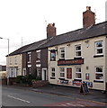
1
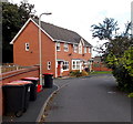
Green Man Close, Wellington
Cul-de-sac on the NE side of Mill Bank.
Image: © Jaggery
Taken: 10 Oct 2013
0.01 miles
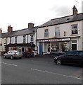
2
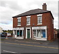
Simply Brides in Wellington
Bridal boutique in Mill Bank.
Image: © Jaggery
Taken: 10 Oct 2013
0.04 miles
3
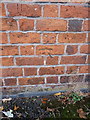
OS benchmark - Wellington, Belfrey Arts Centre
A rather poorly preserved OS cutmark on the front wall of Image; originally levelled at 111.517m above Ordnance Datum Newlyn.
Image: © Richard Law
Taken: 8 Dec 2013
0.05 miles
4
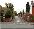
Prince's Street, Wellington
Viewed across Holyhead Road.
Image: © Jaggery
Taken: 10 Oct 2013
0.05 miles
5
Faz Barbers, Wellington
Barber shop in Mill Bank. Next door is Sellagain secondhand furniture store.
Image: © Jaggery
Taken: 10 Oct 2013
0.06 miles
6
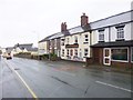
Wellington, Railway Inn
2015 Good Beer Guide-listed pub on Mill Bank. Entrance through passageway to right, with drinking areas and bar left; jukebox, games machine, TV, darts, beer garden. 3 Cask ales available at my visit, from local breweries.
Image: © Mike Faherty
Taken: 13 Oct 2014
0.07 miles
7
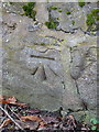
OS benchmark - Wellington, Mill Street
An OS cutmark in a stone wall on the SW side of Mill Street; last levelled by the OS in 1958 at 109.997m above Ordnance Datum Newlyn. It is marked on older maps (1902) at 361.3 ft Liverpool Datum.
Image: © Richard Law
Taken: 8 Dec 2013
0.07 miles
9
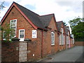
The Belfrey Arts Centre, Wellington
Converted from the old Prince's Street Primary School in 1971, this is now an arts centre for the people of Wellington and Arleston area. Their website is http://www.belfreytheatre.com/
Image: © Richard Law
Taken: 13 Jun 2009
0.08 miles
