IMAGES TAKEN NEAR TO
Church Walk, TELFORD, TF1 1RW
Introduction
This page details the photographs taken nearby to Church Walk, TF1 1RW by members of the Geograph project.
The Geograph project started in 2005 with the aim of publishing, organising and preserving representative images for every square kilometre of Great Britain, Ireland and the Isle of Man.

There are currently over 7.5m images from over14,400 individuals and you can help contribute to the project by visiting https://www.geograph.org.uk
Image Map
Images are licensed for reuse under creativecommons.org/licenses/by-sa/2.0
Notes
- Clicking on the map will re-center to the selected point.
- The higher the marker number, the further away the image location is from the centre of the postcode.
Image Listing (73 Images Found)
Images are licensed for reuse under creativecommons.org/licenses/by-sa/2.0
Image
Details
Distance
1
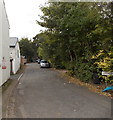
Church Walk, Wellington
Viewed from the Mill Bank end looking towards the east side http://www.geograph.org.uk/photo/3703631 of Christ Church.
Image: © Jaggery
Taken: 10 Oct 2013
0.01 miles
2
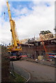
House construction near Christ Church, Wellington
Viewed from Church Walk.
Image: © Jaggery
Taken: 10 Oct 2013
0.02 miles
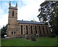
3
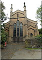
East side of Christ Church, Wellington
Viewed along Church Walk. The Anglican church is in the Diocese of Lichfield.
http://www.geograph.org.uk/photo/3703606 to a view of the south side.
Image: © Jaggery
Taken: 10 Oct 2013
0.02 miles
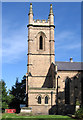
5
South side of Christ Church, Wellington
Anglican church in the Diocese of Lichfield, located between
Church Walk and Mill Bank to the east and New Church Road to the west.
Image: © Jaggery
Taken: 10 Oct 2013
0.03 miles
6
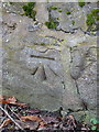
OS benchmark - Wellington, Mill Street
An OS cutmark in a stone wall on the SW side of Mill Street; last levelled by the OS in 1958 at 109.997m above Ordnance Datum Newlyn. It is marked on older maps (1902) at 361.3 ft Liverpool Datum.
Image: © Richard Law
Taken: 8 Dec 2013
0.03 miles
8
Wellington - Christ Church tower
Viewed from the graveyard to the south.
Image: © Dave Bevis
Taken: 22 Sep 2012
0.03 miles
9
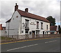
The Olde Kings Head, Wellington
Pub in High Street near the King Street junction.
Image: © Jaggery
Taken: 10 Oct 2013
0.04 miles
10
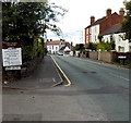
Mill Bank, Wellington
Viewed from the corner of Church Walk http://www.geograph.org.uk/photo/3703643 looking along Mill Bank
towards the junction with High Street and King Street.
Image: © Jaggery
Taken: 10 Oct 2013
0.04 miles