IMAGES TAKEN NEAR TO
The Wyke, SHIFNAL, TF11 9PR
Introduction
This page details the photographs taken nearby to TF11 9PR by members of the Geograph project.
The Geograph project started in 2005 with the aim of publishing, organising and preserving representative images for every square kilometre of Great Britain, Ireland and the Isle of Man.

There are currently over 7.5m images from over14,400 individuals and you can help contribute to the project by visiting https://www.geograph.org.uk
Image Map (Loading...)


Getting Data...Please wait
Leaflet Map data © OpenStreetMap
Images are licensed for reuse under creativecommons.org/licenses/by-sa/2.0
Notes
- Clicking on the map will re-center to the selected point.
- The higher the marker number, the further away the image location is from the centre of the postcode.
Image Listing (38 Images Found)
Images are licensed for reuse under creativecommons.org/licenses/by-sa/2.0
Image
Details
Distance
1
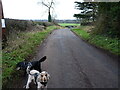
Wyke Lane joins the A4169
The car in the middle distance, just beyond the postbox, is heading NE towards Shifnal.
Image: © Richard Law
Taken: 28 Jan 2023
0.03 miles
2
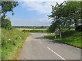
A4169 near the Wyke
Looking along an unclassified road towards a remodelled junction with the A4169. This road was going to be quite a contrast to the long run on paths, private roads and the "quiet lanes" over Nedge Hill.
Image: © Richard Webb
Taken: 30 Jun 2014
0.04 miles
4

A big pile of compost
What looks like manure here is actually several trailer-loads of composted waste from a facility not far from the M54, which processes the compostable garden waste collected locally. In this instance, it's clearly destined to be spread on this field pretty soon.
Image: © Richard Law
Taken: 8 Oct 2021
0.06 miles
6

Down the field towards Stalls
The same field as Image but in this case a little further north, and looking down the hedgeline towards the small former cattle shed known as Stalls in the far corner, which is now a rural office premises.
Image: © Richard Law
Taken: 8 Oct 2021
0.08 miles
7
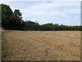
Corner of a field east of The Wyke
The wheat here has recently been harvested, so the opportunity to walk the dogs and take a couple of photos was taken
Image: © Richard Law
Taken: 5 Sep 2022
0.09 miles
8
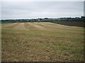
Looking down the field towards The Manor
The same field as Image and looking pretty much in the opposite direction to that picture
Image: © Richard Law
Taken: 8 Oct 2021
0.11 miles
9
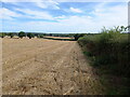
Field boundary near The Wyke
Looking along the hedgeline that defines the southern edge of this recently-harvested field.
Image: © Richard Law
Taken: 5 Sep 2022
0.11 miles
10
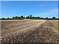
Rape stubble in the autumn
A different corner, but basically the same field as Image, taken shortly after the crop of rape had been harvested. The field has had a layer of composted garden waste spread on it, as fertiliser for next year.
Image: © Richard Law
Taken: 9 Aug 2022
0.11 miles