IMAGES TAKEN NEAR TO
Nedge Hill, SHIFNAL, TF11 9PL
Introduction
This page details the photographs taken nearby to TF11 9PL by members of the Geograph project.
The Geograph project started in 2005 with the aim of publishing, organising and preserving representative images for every square kilometre of Great Britain, Ireland and the Isle of Man.

There are currently over 7.5m images from over14,400 individuals and you can help contribute to the project by visiting https://www.geograph.org.uk
Image Map (Loading...)


Getting Data...Please wait
Leaflet Map data © OpenStreetMap
Images are licensed for reuse under creativecommons.org/licenses/by-sa/2.0
Notes
- Clicking on the map will re-center to the selected point.
- The higher the marker number, the further away the image location is from the centre of the postcode.
Image Listing (16 Images Found)
Images are licensed for reuse under creativecommons.org/licenses/by-sa/2.0
Image
Details
Distance
1
View from a Telford-Ironbridge train - Nedge Farm
Image: © Nigel Thompson
Taken: 9 Jun 2019
0.01 miles
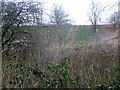
2
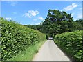
Naird Lane
On the steep climb up Nedge Hill.
Image: © Richard Webb
Taken: 30 Jun 2014
0.15 miles
3
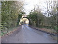
Railway bridge crossing Nairn Road
Railway bridge crossing Nairn Road near Stirchley
Image: © Philip Halling
Taken: 28 Aug 2018
0.17 miles
4
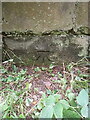
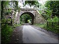
OS benchmark - Naird Lane
An OS cutmark low on the bridge seen in Image which was cut in 1961, and last levelled 20-odd years later at 110.100m above Ordnance Datum Newlyn.
Image: © Richard Law
Taken: 25 Aug 2024
0.17 miles
5
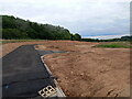
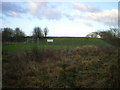
Preparatory works for new housing
The planning application tucked into the gateway where I took this image states that the site is going to have "299no. dwellings with all supporting infrastructure ... roundabout access, road & footpath network, SuDS features, open space & landscaping" etc.
Ironically there was another sign attached to the site fencing which rather optimistically said "Tree protection". Given the evident amount of ground clearance, coupled with the fact that this photo is taken almost directly along the line of a former field boundary/hedge, it's hard to see how many trees have been protected. Still, such is the cost of progress.
Image: © Richard Law
Taken: 14 Jul 2024
0.17 miles

7
Railway Bridge
On the Stafford Park to Iron Bridge Power Station branch line.
Image: © Paul Beaman
Taken: 14 Jan 2007
0.18 miles
8
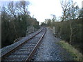
The single track line to Ironbridge Power Station
The track crosses the lower end of Nedge Lane at this bridge, seen from the road in Image
Image: © Richard Law
Taken: 17 Dec 2009
0.18 miles
9
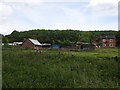
Nedge Hill
I used the narrow minor road to car park then explored woodland and ground between woodland and reservoir.
Name: Nedge Hill
Hill number: 17182
Height: 166m / 545ft
Parent (Ma/M): 2843 The Wrekin
Section: 38A: Shropshire
County/UA: Telford and Wrekin (UA)
County/UA: Shropshire (CoU)
Class: Tump (100-199m)
Grid ref: SJ 71792 07333
Summit feature: no feature: ground between mast and reservoir
Drop: 35m
Col: 131m SJ715080
Image: © Rude Health
Taken: 25 Mar 2015
0.19 miles