IMAGES TAKEN NEAR TO
Haughton Hill, SHIFNAL, TF11 9PE
Introduction
This page details the photographs taken nearby to TF11 9PE by members of the Geograph project.
The Geograph project started in 2005 with the aim of publishing, organising and preserving representative images for every square kilometre of Great Britain, Ireland and the Isle of Man.

There are currently over 7.5m images from over14,400 individuals and you can help contribute to the project by visiting https://www.geograph.org.uk
Image Map (Loading...)


Getting Data...Please wait
Leaflet Map data © OpenStreetMap
Images are licensed for reuse under creativecommons.org/licenses/by-sa/2.0
Notes
- Clicking on the map will re-center to the selected point.
- The higher the marker number, the further away the image location is from the centre of the postcode.
Image Listing (4 Images Found)
Images are licensed for reuse under creativecommons.org/licenses/by-sa/2.0
Image
Details
Distance
1
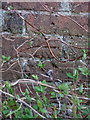
OS benchmark - Shifnal, 25 Haughtonhill
An OS cutmark in the bricks of the northernmost of a pair of semi-detached farm cottages at Haughtonhill; originally levelled at 124.011m above Ordnance Datum Newlyn.
Image: © Richard Law
Taken: 15 Feb 2014
0.00 miles
2
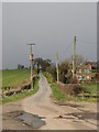
It's All Uphill
Grey skies over Haughton Hill and snow showers looming!
Image: © Paul Beaman
Taken: 22 Mar 2008
0.01 miles
3
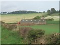
Haughtonhill
Small farm and outbuildings at Haughtonhill. The main farm and large farmhouse are at the top of the hill.
Image: © John M
Taken: 12 Oct 2006
0.03 miles
4
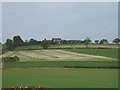
Haughtonhill and Haughtonhill Farm
Situated right on the top of a hill and up a long farm road.
Image: © John M
Taken: 12 Oct 2006
0.11 miles