IMAGES TAKEN NEAR TO
Hall Lane, SHIFNAL, TF11 9LQ
Introduction
This page details the photographs taken nearby to Hall Lane, TF11 9LQ by members of the Geograph project.
The Geograph project started in 2005 with the aim of publishing, organising and preserving representative images for every square kilometre of Great Britain, Ireland and the Isle of Man.

There are currently over 7.5m images from over14,400 individuals and you can help contribute to the project by visiting https://www.geograph.org.uk
Image Map (Loading...)


Getting Data...Please wait
Leaflet Map data © OpenStreetMap
Images are licensed for reuse under creativecommons.org/licenses/by-sa/2.0
Notes
- Clicking on the map will re-center to the selected point.
- The higher the marker number, the further away the image location is from the centre of the postcode.
Image Listing (24 Images Found)
Images are licensed for reuse under creativecommons.org/licenses/by-sa/2.0
Image
Details
Distance
1
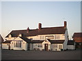
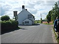
End of an 8 mile walk & they're closed - arghhhh
This is the Masons Arms. A very nice pub with very good food. Problem was I couldn't enjoy the place as it was closed until early evening & it was only late afternoon. Picture taken from the car park.
Image: © Row17
Taken: 18 Feb 2008
0.03 miles
2
5 Hall Lane, Kemberton
Outwardly nothing particularly special to look at, no 5 is actually an early 18th century (1734) cottage with at least partial timber framing, and was Grade II listed https://britishlistedbuildings.co.uk/101239272-5-hall-lane-kemberton#.XqdM-WhKjcs & https://historicengland.org.uk/listing/the-list/list-entry/1239272 in 1984.
Image: © Richard Law
Taken: 26 Apr 2020
0.03 miles
3
Mason's Arms, Kimberton
On the route of the Monarch’s Way long distance footpath
Image: © John Sparshatt
Taken: 17 Nov 2012
0.04 miles
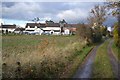
5
Hall Lane
Walking West out of Kemberton.
Image: © Gordon Griffiths
Taken: 14 May 2007
0.09 miles
6
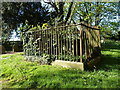
The John & Sarah Ward Memorial in Kemberton
A railed chest tomb enclosure to the memory of John & Sarah Ward of the village, who died in 1797 & 1807 respectively, and which was Grade II listed https://britishlistedbuildings.co.uk/101239309-john-and-sarah-ward-memorial-and-railed-enclosure-about-5-metres-west-of-the-tower-of-st-andrew-kemberton#.Xp8TB8hKjcs & https://historicengland.org.uk/listing/the-list/list-entry/1239309 in 1984.
Image: © Richard Law
Taken: 20 Apr 2020
0.09 miles
7
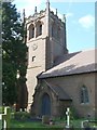
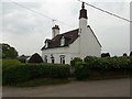
Kemberton Church
St. Andrew's Church
Image: © Gordon Griffiths
Taken: 14 May 2007
0.10 miles
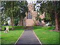
8
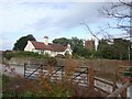
Church Farm
The houses and farms surrounding the church have private gates into the churchyard.
Image: © John M
Taken: 29 Aug 2009
0.10 miles
9
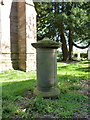
Monument to John Cherrington, Kemberton
A rather unusual cylindrical sandstone monument/tomb for John Cherrington of the village, who died in 1817, and which was Grade II listed https://britishlistedbuildings.co.uk/101273841-monument-to-john-cherrington-about-5-metres-west-of-the-tower-of-the-church-of-st-andrew-kemberton#.Xp8UnMhKjcs & https://historicengland.org.uk/listing/the-list/list-entry/1273841 in 1984.
Image: © Richard Law
Taken: 20 Apr 2020
0.10 miles
10
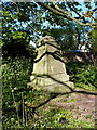
Pyramidal monument in Kemberton
An unusual tomb or monument to an unknown local (the inscription has weathered away) which attracted a Grade II listing https://britishlistedbuildings.co.uk/101239200-pyramidal-monument-about-14-metres-north-west-of-the-tower-of-the-church-of-st-andrew-kemberton#.Xp8VbchKjcs https://historicengland.org.uk/listing/the-list/list-entry/1239200 in 1984.
Image: © Richard Law
Taken: 20 Apr 2020
0.10 miles