IMAGES TAKEN NEAR TO
Field Lane, SHIFNAL, TF11 9LP
Introduction
This page details the photographs taken nearby to Field Lane, TF11 9LP by members of the Geograph project.
The Geograph project started in 2005 with the aim of publishing, organising and preserving representative images for every square kilometre of Great Britain, Ireland and the Isle of Man.

There are currently over 7.5m images from over14,400 individuals and you can help contribute to the project by visiting https://www.geograph.org.uk
Image Map (Loading...)


Getting Data...Please wait
Leaflet Map data © OpenStreetMap
Images are licensed for reuse under creativecommons.org/licenses/by-sa/2.0
Notes
- Clicking on the map will re-center to the selected point.
- The higher the marker number, the further away the image location is from the centre of the postcode.
Image Listing (17 Images Found)
Images are licensed for reuse under creativecommons.org/licenses/by-sa/2.0
Image
Details
Distance
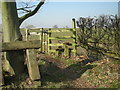
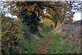
4
View from Stile
Scene from footpath north of Kemberton.
Image: © Gordon Griffiths
Taken: 14 May 2007
0.17 miles
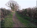
5
Enclosed footpath
Approaching Kemberton on the Monarch’s Way long distance footpath
Image: © John Sparshatt
Taken: 17 Nov 2012
0.18 miles
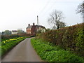
7
Footpath off Grooms Lane, Kemberton
The maps show the path running across the field just to the south of this point, but it appears to have been diverted (and signed by the council) along this trackway. Has proven to be a good source of blackberries in past autumns.
Image: © Richard Law
Taken: 9 Apr 2020
0.18 miles
8
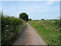
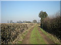
Field Lane out of Kemberton
The clump of trees just above the hedge on the right is actually on top of the nearby Lodge Hill in Image, a popular local walk and sometime sledging venue.
Image: © Richard Law
Taken: 14 Jul 2013
0.19 miles
9
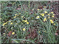
Lesser Celandine flowering near Kemberton
This Lesser Celandine (Ranunculus ficaria) is one of a number of spring wildflowers along the path just east of Kemberton. The plant is a species of buttercup.
Image: © Richard Law
Taken: 9 Apr 2020
0.19 miles
10

Another disappearing pond, this time at Kemberton
Another pond from the 1:25k map, becoming more and more overgrown and infilled by the encroaching vegetation.
Image: © Richard Law
Taken: 18 Dec 2009
0.21 miles