IMAGES TAKEN NEAR TO
Kemberton, SHIFNAL, TF11 9LB
Introduction
This page details the photographs taken nearby to TF11 9LB by members of the Geograph project.
The Geograph project started in 2005 with the aim of publishing, organising and preserving representative images for every square kilometre of Great Britain, Ireland and the Isle of Man.

There are currently over 7.5m images from over14,400 individuals and you can help contribute to the project by visiting https://www.geograph.org.uk
Image Map (Loading...)


Getting Data...Please wait
Leaflet Map data © OpenStreetMap
Images are licensed for reuse under creativecommons.org/licenses/by-sa/2.0
Notes
- Clicking on the map will re-center to the selected point.
- The higher the marker number, the further away the image location is from the centre of the postcode.
Image Listing (11 Images Found)
Images are licensed for reuse under creativecommons.org/licenses/by-sa/2.0
Image
Details
Distance
1

Flush Bracket G3462 - Langley House
OS Flush Bracket is mounted low on the south facing wall of Langley House, behind a small shrub which the owner kindly cut back to allow me to see the bracket. I've long known this place as Kemberton Quarters, due to its alleged use during the English Civil War as a barracks.
Image: © Richard Law
Taken: 14 Jul 2013
0.00 miles
2
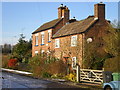
Kemberton Quarters
Now known as Langton House and Langton Cottage, this has always been known locally as 'Kemberton Quarters' and was allegedly used in the Civil War as a military barracks (hence the name). I am struggling to verify this information, so if anyone can enlighten me, feel free.
Image: © Richard Law
Taken: 18 Dec 2009
0.02 miles
3
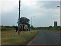
Junction with a horse drawn caravan near Kemberton
The wide verge at the junction provided space for the caravan and food for the horse
Image: © David Smith
Taken: 23 Jul 2013
0.04 miles
4
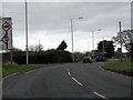
B4379 approaches the A4169 junction
The B road "disappears" here, but the number is used again for the link between Shifnal and the A41 north of Heath Hill.
Image: © Peter Whatley
Taken: 29 Nov 2011
0.06 miles
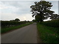
5
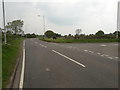
The junction of Hall Lane with the B4379
Hall Lane is the main route into Kemberton from the west, accessed at this junction.
Image: © Richard Law
Taken: 26 Apr 2020
0.07 miles
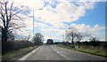
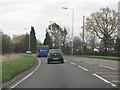
7
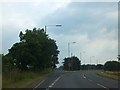
B4379 fork off A4169
A well-lit junction (count the lamp-posts) where traffic heading towards Ludlow forks off the road to the south of Telford
Image: © David Smith
Taken: 23 Jul 2013
0.15 miles