IMAGES TAKEN NEAR TO
Ryton, SHIFNAL, TF11 9JL
Introduction
This page details the photographs taken nearby to TF11 9JL by members of the Geograph project.
The Geograph project started in 2005 with the aim of publishing, organising and preserving representative images for every square kilometre of Great Britain, Ireland and the Isle of Man.

There are currently over 7.5m images from over14,400 individuals and you can help contribute to the project by visiting https://www.geograph.org.uk
Image Map (Loading...)


Getting Data...Please wait
Leaflet Map data © OpenStreetMap
Images are licensed for reuse under creativecommons.org/licenses/by-sa/2.0
Notes
- Clicking on the map will re-center to the selected point.
- The higher the marker number, the further away the image location is from the centre of the postcode.
Image Listing (54 Images Found)
Images are licensed for reuse under creativecommons.org/licenses/by-sa/2.0
Image
Details
Distance
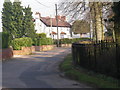
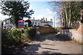
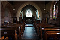
2
Ryton Scene
The view in Ryton Village towards St Andrew's church.
Image: © Gordon Griffiths
Taken: 26 Feb 2016
0.04 miles
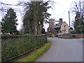
3
Cottage and Church, Ryton
The church, unusually, is not dedicated to any particular Saint
Image: © Geoff Pick
Taken: 16 Sep 2006
0.05 miles
6
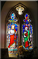
Stained glass window, St Andrews Church, Ryton
Image: © Ian S
Taken: 31 Mar 2016
0.08 miles
7
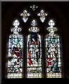
Stained glass window, St Andrews Church, Ryton
Image: © Ian S
Taken: 31 Mar 2016
0.08 miles
8
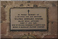
Wilfrid Bernard Foster
Memorial plaque in St Andrews Church, Ryton.
Image: © Ian S
Taken: 31 Mar 2016
0.08 miles
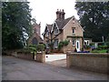
10

OS benchmark - Ryton church
OS benchmark on the W face, near the SW angle of the church tower. Originally levelled at 73.931m above Ordnance Datum Newlyn.
Image: © Richard Law
Taken: 18 Aug 2013
0.08 miles