IMAGES TAKEN NEAR TO
Hatton, SHIFNAL, TF11 9HW
Introduction
This page details the photographs taken nearby to TF11 9HW by members of the Geograph project.
The Geograph project started in 2005 with the aim of publishing, organising and preserving representative images for every square kilometre of Great Britain, Ireland and the Isle of Man.

There are currently over 7.5m images from over14,400 individuals and you can help contribute to the project by visiting https://www.geograph.org.uk
Image Map (Loading...)


Getting Data...Please wait
Leaflet Map data © OpenStreetMap
Images are licensed for reuse under creativecommons.org/licenses/by-sa/2.0
Notes
- Clicking on the map will re-center to the selected point.
- The higher the marker number, the further away the image location is from the centre of the postcode.
Image Listing (4 Images Found)
Images are licensed for reuse under creativecommons.org/licenses/by-sa/2.0
Image
Details
Distance
1
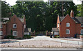
Lodges near Shifnal
Rather than actual lodges, possibly just a pair of cottages by a drive to the Hatton Grange estate.
Image: © Stephen Richards
Taken: Unknown
0.02 miles
2
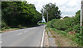
Holyhead Road near Shifnal
The A464 heading towards Shifnal.
Image: © Stephen Richards
Taken: Unknown
0.10 miles
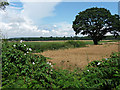
4
Potato field near Common Farm
Just off the A464 south-east of Shifnal.
Image: © Jonathan Billinger
Taken: 22 May 2007
0.23 miles