IMAGES TAKEN NEAR TO
Lower Upton, SHIFNAL, TF11 9HG
Introduction
This page details the photographs taken nearby to TF11 9HG by members of the Geograph project.
The Geograph project started in 2005 with the aim of publishing, organising and preserving representative images for every square kilometre of Great Britain, Ireland and the Isle of Man.

There are currently over 7.5m images from over14,400 individuals and you can help contribute to the project by visiting https://www.geograph.org.uk
Image Map (Loading...)


Getting Data...Please wait
Leaflet Map data © OpenStreetMap
Images are licensed for reuse under creativecommons.org/licenses/by-sa/2.0
Notes
- Clicking on the map will re-center to the selected point.
- The higher the marker number, the further away the image location is from the centre of the postcode.
Image Listing (6 Images Found)
Images are licensed for reuse under creativecommons.org/licenses/by-sa/2.0
Image
Details
Distance
1
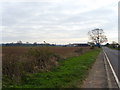
Lower Upton Farm
From along the A464 leaving Shifnal.
Image: © A Holmes
Taken: 7 Apr 2007
0.04 miles
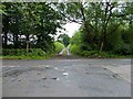
2
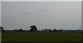
Lower Upton Farm from the railway
Image: © Christopher Hilton
Taken: 9 Jun 2016
0.06 miles
4
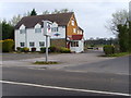
Cafe Monsoon
On the corner of Bonemill Lane.
Image: © A Holmes
Taken: 9 Apr 2007
0.23 miles
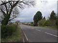
6
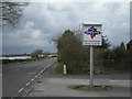
Monarch's Way, looking south-west
This long distance walking route crosses the A464 Shifnal to Wolverhampton road here.
The sign on the leaning fingerpost reads:
"The Monarch's Way. A 610-mile walking trail following the escape of Charles II after the battle of Worcester in 1651. Devised and promoted by the Monarch's Way association."
Further information: http://www.monarchsway.50megs.com
Image: © Mike White
Taken: 17 Jun 2009
0.24 miles