IMAGES TAKEN NEAR TO
Village Road, SHIFNAL, TF11 9ED
Introduction
This page details the photographs taken nearby to Village Road, TF11 9ED by members of the Geograph project.
The Geograph project started in 2005 with the aim of publishing, organising and preserving representative images for every square kilometre of Great Britain, Ireland and the Isle of Man.

There are currently over 7.5m images from over14,400 individuals and you can help contribute to the project by visiting https://www.geograph.org.uk
Image Map (Loading...)


Getting Data...Please wait
Leaflet Map data © OpenStreetMap
Images are licensed for reuse under creativecommons.org/licenses/by-sa/2.0
Notes
- Clicking on the map will re-center to the selected point.
- The higher the marker number, the further away the image location is from the centre of the postcode.
Image Listing (34 Images Found)
Images are licensed for reuse under creativecommons.org/licenses/by-sa/2.0
Image
Details
Distance
2
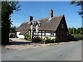
24 Village Road, Norton
17th century, timber-framed and thatched, and Grade II listed https://britishlistedbuildings.co.uk/101053782-24-village-road-stockton#.XaQaguhKhPY & https://historicengland.org.uk/listing/the-list/list-entry/1053782 in 1974. The roof has fairly recently been renewed, very tidily.
Image: © Richard Law
Taken: 24 Aug 2019
0.06 miles
3
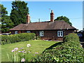
Nos 5 & 6 Village Road, Norton
Nominally rather plain and unremarkable, but these rare early 19th century estate cottages, with their outbuildings at the rear, were Grade II listed https://britishlistedbuildings.co.uk/101379959-nos5-and-6-including-outbuildings-to-rear-stockton#.XaQb9-hKhPY & https://historicengland.org.uk/listing/the-list/list-entry/1379959 in 2000. The outbuildings were formerly wash-houses, pigsties and stores.
Image: © Richard Law
Taken: 24 Aug 2019
0.08 miles
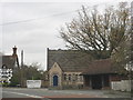
4
The "Old School", Village Road, Norton
Image: © Jeff Tomlinson
Taken: 27 Sep 2008
0.09 miles
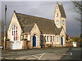
6
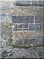
OS benchmark - Norton, the old school
An OS cutmark on the corner buttress of the building, just behind the white gates on the left of http://www.geograph.org.uk/photo/1729985. Originally levelled at 75.859m above Ordnance Datum Newlyn.
Image: © Richard Law
Taken: 27 Sep 2014
0.11 miles
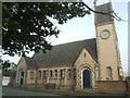
7
Norton Church
The roof tiles' pattern is exquisite.
Image: © Peter Whatley
Taken: 29 Nov 2011
0.11 miles
8
The village stocks and the bus stop in Norton
Image: © Richard Law
Taken: 27 Feb 2010
0.11 miles
9
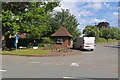
The A442 at Norton
This shows the preserved set of stocks and adjoining bus shelter opposite The Hundred House public house (out of sight to the right). I have driven past here many times but it took a friend to point out the stocks and make a special stop for a look.
Image: © Chris Allen
Taken: 9 Jun 2019
0.11 miles
10
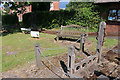
Stocks, Norton
Alongside the A442 and with a reminder of WWI behind - lest we forget. The stocks are interesting in having separate manacles for miscreants other than those sat in the stocks.
Image: © Chris Allen
Taken: 9 Jun 2019
0.11 miles