IMAGES TAKEN NEAR TO
Norton, SHIFNAL, TF11 9DU
Introduction
This page details the photographs taken nearby to TF11 9DU by members of the Geograph project.
The Geograph project started in 2005 with the aim of publishing, organising and preserving representative images for every square kilometre of Great Britain, Ireland and the Isle of Man.

There are currently over 7.5m images from over14,400 individuals and you can help contribute to the project by visiting https://www.geograph.org.uk
Image Map
Images are licensed for reuse under creativecommons.org/licenses/by-sa/2.0
Notes
- Clicking on the map will re-center to the selected point.
- The higher the marker number, the further away the image location is from the centre of the postcode.
Image Listing (4 Images Found)
Images are licensed for reuse under creativecommons.org/licenses/by-sa/2.0
Image
Details
Distance
1
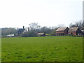
Old Park farmhouse and buildings
The name comes from the 'Old Park', features of which are still apparently visible in cropmarks in the nearby fields. The main farmhouse building dates from the 16th Century, and sits within a moated, defensive site which is a recorded by Historic England as a Scheduled Monument https://historicengland.org.uk/listing/the-list/list-entry/1020371. The whole area is part of the nearby Apley Estate.
Image: © Richard Law
Taken: 10 Apr 2010
0.01 miles
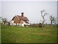
2
Remains of the moat at Old Park
This is the clearest part of the earthworks enclosing the moat around Old Park Farm; there is also a section with a small amount of water in it, and another rather boggy area on the other side of the house.
Image: © Richard Law
Taken: 10 Apr 2010
0.02 miles
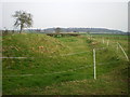
3
Water in the moat at Old Park Farm
The one remaining area of flooded moat at Old Park Farm - it's not deep, but it's definitely wet.
Image: © Richard Law
Taken: 10 Apr 2010
0.02 miles