
IMAGES TAKEN NEAR TO
Snowdon Road, SHIFNAL, TF11 9DH
Introduction
This page details the photographs taken nearby to Snowdon Road, TF11 9DH by members of the Geograph project.
The Geograph project started in 2005 with the aim of publishing, organising and preserving representative images for every square kilometre of Great Britain, Ireland and the Isle of Man.

There are currently over 7.5m images from over14,400 individuals and you can help contribute to the project by visiting https://www.geograph.org.uk
Image Map
Images are licensed for reuse under creativecommons.org/licenses/by-sa/2.0
Notes
- Clicking on the map will re-center to the selected point.
- The higher the marker number, the further away the image location is from the centre of the postcode.
Image Listing (34 Images Found)
Images are licensed for reuse under creativecommons.org/licenses/by-sa/2.0
Image
Details
Distance
1
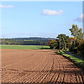
Farmland by Snowdon Lane near Beckbury, Shropshire
Looking east towards Burnhill Green. Woodland of Rous's Covert is on the skyline.
The fields are part of Heath House Farm land.
Image: © Roger Kidd
Taken: 8 Oct 2022
0.03 miles
2
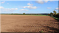
Shropshire farmland east of Beckbury
Looking north-east from the edge of Beckbury village, Snowdon Lane is just visible on the right, leading towards Burnhill Green. Woodland of Rous's Covert is on the skyline.
Image: © Roger Kidd
Taken: 8 Oct 2022
0.10 miles
3
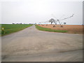
Farmland east of Beckbury
A view along the bridleway to Heath House Farm, past one of their enormous irrigators. Irrigation in early April - what's that all about?
Image: © Richard Law
Taken: 10 Apr 2010
0.11 miles
4

Beckbury Primary school
This is the original part of the school, built, according to the plaque in the central 'gable', in 1872. The newer school buildings are demountables, erected at the rear. Beckbury School seems destined to close in 2009, as part of the current rationalisation of primary education in Shropshire, after which this will doubtless join the growing ranks of conversions to private houses.
Image: © Richard Law
Taken: 14 Dec 2008
0.13 miles
5
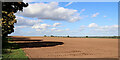
Shropshire farmland east of Beckbury
At the edge of Beckbury village, and looking north-north-east from Snowdon Lane towards Heath House Farm. A bridleway leads along the edge of the field.
Image: © Roger Kidd
Taken: 8 Oct 2022
0.13 miles
6
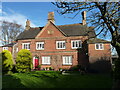
Former Beckbury C of E Primary School
Last photographed about 10 years ago Image at which time it was apparently still in use as a school; as predicted it's now a private house. It was built in 1852 by a local man called J V Hand, and opened as a school the following year. Grade II listed https://britishlistedbuildings.co.uk/101367599-beckbury-church-of-england-primary-school-beckbury#.YHvnDuhKjIU & https://historicengland.org.uk/listing/the-list/list-entry/1367599 in 1984.
Image: © Richard Law
Taken: 23 Feb 2020
0.14 miles
7
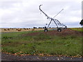
Watering Rig
The view off Snowdon Lane near Big Wood Farm.
Image: © Gordon Griffiths
Taken: 20 Aug 2010
0.14 miles
8
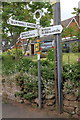
Old Direction Sign - Signpost by Badger Lane, Beckbury
Annulus finial - 3 arms; Shropshire CC modern halo by the UC road, in parish of Beckbury (Bridgnorth District), junction of Badger Lane with Snowdon Lane, on pavement, against low stone garden wall, West side of road.
Surveyed
Milestone Society National ID: SA_SJ7601C
Image: © Milestone Society
Taken: Unknown
0.16 miles
9
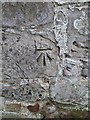
OS benchmark - Beckbury, Badger Lane wall
An OS cutmark in the stonework bounding the west side of Badger Lane in Beckbury; originally levelled in 1959 at 90.826m above Ordnance Datum Newlyn.
Image: © Richard Law
Taken: 20 Jul 2014
0.16 miles
10
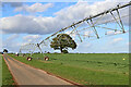
Irrigation equipment on farmland near Beckbury in Shropshire
Wonderful contraption, on Heath House Farm land east of Beckbury. This looks like the same rig I saw in 2007 nearby. Image] I have measured it on an aerial image and it is about 175 metres in length!
A bridleway also uses the private farm road, joining another bridleway near the farm which is used by the Monarch's Way and the Cross Britain Way.
Image: © Roger Kidd
Taken: 8 Oct 2022
0.18 miles