IMAGES TAKEN NEAR TO
Church Meadow, SHIFNAL, TF11 9AD
Introduction
This page details the photographs taken nearby to Church Meadow, TF11 9AD by members of the Geograph project.
The Geograph project started in 2005 with the aim of publishing, organising and preserving representative images for every square kilometre of Great Britain, Ireland and the Isle of Man.

There are currently over 7.5m images from over14,400 individuals and you can help contribute to the project by visiting https://www.geograph.org.uk
Image Map
Images are licensed for reuse under creativecommons.org/licenses/by-sa/2.0
Notes
- Clicking on the map will re-center to the selected point.
- The higher the marker number, the further away the image location is from the centre of the postcode.
Image Listing (413 Images Found)
Images are licensed for reuse under creativecommons.org/licenses/by-sa/2.0
Image
Details
Distance
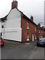
1
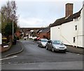
Church Meadow, Shifnal
Cul-de-sac on the north side of Church Street. A railway viaduct is in the background.
Image: © Jaggery
Taken: 26 Nov 2015
0.02 miles
2
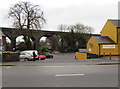
Railway viaduct, Shifnal
Part of a long viaduct west of Shifnal railway station.
This section is opposite Victoria Road, about 130 metres from the western end of the station.
Image: © Jaggery
Taken: 26 Nov 2015
0.03 miles
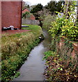
3
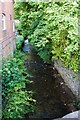
Wesley Brook south of Victoria Rd
It's closely confined by walls here.
Image: © Mike White
Taken: 14 Jun 2009
0.04 miles
4
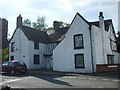
Old Idsall House
Believed to be the oldest House in Shifnal,and to have survived the fire of 1591. From about 1760 it was Shifnal's first Post Office.
Image: © Gordon Griffiths
Taken: 14 May 2007
0.04 miles
5
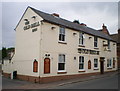
The Old Bell, Shifnal
A free house in Church Street, which ceased trading as a public house not long after this picture was taken; it's currently (2015) operating as a French-themed restaurant and bistro/bar Image
Image: © Richard Law
Taken: 22 May 2009
0.05 miles
6
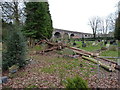
Windfallen tree in St Andrew's churchyard
One of 4 victim trees in the churchyard of Storm Doris, which blew across the country in late February 2017. This large evergreen came down near the railway embankment, along with a silver birch and a couple of ornamental larches elsewhere in the area.
Image: © Richard Law
Taken: 24 Feb 2017
0.05 miles
7
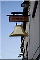
Old Bell Inn pub sign
It's a bell, all right.
Image: © Mike White
Taken: 14 Jun 2009
0.05 miles
8
Wesley Brook flows toward Church Street, Shifnal
Viewed from the north side of Church Street. Wesley Brook is a tributary of the River Worfe.
Image: © Jaggery
Taken: 26 Nov 2015
0.05 miles
9
32 Church Street, Shifnal
This end-of-terrace house dates from the early 18th century, and despite many changes over the years, it retains a number of period features, particularly indoors. It was refaced in brick in the late 18th, and attracted a Grade II listing https://britishlistedbuildings.co.uk/101278002-32-church-street-shifnal#.Xyr48ihKjcs &https://historicengland.org.uk/listing/the-list/list-entry/1278002 in 1992.
Image: © Richard Law
Taken: 4 Aug 2020
0.06 miles
10
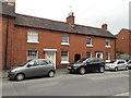
28 & 30 Church Street, Shifnal
A pair of semi-detached terraced cottages, dating from the late 18th century, and which collectively attracted a Grade II listing https://britishlistedbuildings.co.uk/101278027-28-and-30-church-street-shifnal#.Xyr5_ShKjcs & https://historicengland.org.uk/listing/the-list/list-entry/1278027 in 1992.
Image: © Richard Law
Taken: 4 Aug 2020
0.06 miles