IMAGES TAKEN NEAR TO
Sheriffhales, SHIFNAL, TF11 8RQ
Introduction
This page details the photographs taken nearby to TF11 8RQ by members of the Geograph project.
The Geograph project started in 2005 with the aim of publishing, organising and preserving representative images for every square kilometre of Great Britain, Ireland and the Isle of Man.

There are currently over 7.5m images from over14,400 individuals and you can help contribute to the project by visiting https://www.geograph.org.uk
Image Map (Loading...)


Getting Data...Please wait
Leaflet Map data © OpenStreetMap
Images are licensed for reuse under creativecommons.org/licenses/by-sa/2.0
Notes
- Clicking on the map will re-center to the selected point.
- The higher the marker number, the further away the image location is from the centre of the postcode.
Image Listing (7 Images Found)
Images are licensed for reuse under creativecommons.org/licenses/by-sa/2.0
Image
Details
Distance
2
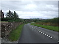
B4379 towards Sheriffhales
A downhill, twisty stretch.
Image: © JThomas
Taken: 10 Aug 2019
0.02 miles
4
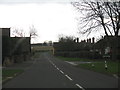
Sherriffhales - B4379 at Kettlemore Lane
Image: © Peter Whatley
Taken: 29 Nov 2011
0.18 miles
5
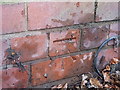
OS benchmark - Heath Hill former pumping station
An OS cutmark on the former Severn Trent pumping station at the top of the hill out of Sheriffhales; originally levelled at 153.004m above Ordnance Datum Newlyn.
Image: © Richard Law
Taken: 19 Dec 2014
0.21 miles
6
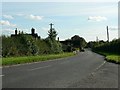
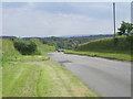
Sheriffhales from the north
The B4379 as it enters Sheriffhales.
Image: © Rich Tea
Taken: 26 Sep 2006
0.24 miles
7
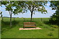
Cyclist's seat
At a road junction near Lilleshall.
Image: © John M
Taken: 8 Jun 2013
0.24 miles