IMAGES TAKEN NEAR TO
Lilyhurst, SHIFNAL, TF11 8RJ
Introduction
This page details the photographs taken nearby to TF11 8RJ by members of the Geograph project.
The Geograph project started in 2005 with the aim of publishing, organising and preserving representative images for every square kilometre of Great Britain, Ireland and the Isle of Man.

There are currently over 7.5m images from over14,400 individuals and you can help contribute to the project by visiting https://www.geograph.org.uk
Image Map (Loading...)


Getting Data...Please wait
Leaflet Map data © OpenStreetMap
Images are licensed for reuse under creativecommons.org/licenses/by-sa/2.0
Notes
- Clicking on the map will re-center to the selected point.
- The higher the marker number, the further away the image location is from the centre of the postcode.
Image Listing (6 Images Found)
Images are licensed for reuse under creativecommons.org/licenses/by-sa/2.0
Image
Details
Distance
2
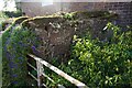
9 Lilyhurst Road Benchmark
The Ordnance Survey Benchmark cut into the garden wall of 9 Lilyhurst Road, Lilleshall, Telford. The Benchmark was first levelled by the OS in 19th Century and was last verified in 1961. It's height above the Ordnance Datum at Newlyn is recorded as 140.059-metres.
Image: © Anthony Rowley
Taken: 24 Mar 2022
0.15 miles
3
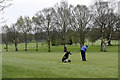
Lilleshall Hall Golf Course
5813 yards, SSS 68.
Image: © Andy Stephenson
Taken: 17 Apr 2005
0.19 miles
5
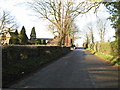
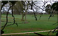
Lilyhurst
Lilyhurst,on the road from Sheriffhales to Lilleshall.
Image: © Paul Beaman
Taken: 21 Jan 2007
0.21 miles
6
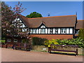
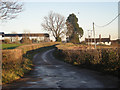
Lilleshall Golf Club
Pear Tree Lodge , Club House for the golf club.
Image: © A Holmes
Taken: 28 Apr 2007
0.24 miles