IMAGES TAKEN NEAR TO
The Rock, SHIFNAL, TF11 8RB
Introduction
This page details the photographs taken nearby to The Rock, TF11 8RB by members of the Geograph project.
The Geograph project started in 2005 with the aim of publishing, organising and preserving representative images for every square kilometre of Great Britain, Ireland and the Isle of Man.

There are currently over 7.5m images from over14,400 individuals and you can help contribute to the project by visiting https://www.geograph.org.uk
Image Map (Loading...)


Getting Data...Please wait
Leaflet Map data © OpenStreetMap
Images are licensed for reuse under creativecommons.org/licenses/by-sa/2.0
Notes
- Clicking on the map will re-center to the selected point.
- The higher the marker number, the further away the image location is from the centre of the postcode.
Image Listing (23 Images Found)
Images are licensed for reuse under creativecommons.org/licenses/by-sa/2.0
Image
Details
Distance
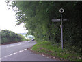
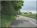
1
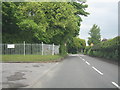
B4379 approaching Marsh Road, Sheriffhales
Image: © Peter Whatley
Taken: 29 May 2013
0.03 miles
4
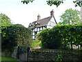
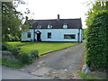
Fallows house in Sheriffhales
17th century in origin, albeit with some additions and enhancements over the years. The house attracted a Grade II listing status https://britishlistedbuildings.co.uk/101053648 & https://historicengland.org.uk/listing/the-list/list-entry/1053648 in 1984.
Image: © Richard Law
Taken: 8 May 2020
0.16 miles
5
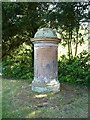
The Gorser memorial in Sheriffhales
A late 18th century burial memorial to a number of members of the Gorser family, the earliest still-legible inscription on it being to a gentleman who died in the 1790s. It was Grade II listed https://britishlistedbuildings.co.uk/101053646-gorser-tomb-approximately-18-metres-to-the-south-of-the-chancel-of-church-of-st-mary-sheriffhales#.YK6wMahKhPY & https://historicengland.org.uk/listing/the-list/list-entry/1053646 in 1984.
Image: © Richard Law
Taken: 8 May 2020
0.17 miles
6
Sheriffhales War Memorial
Erected in a field just to the south of the churchyard which is now used for burials, and dating from around 1920. The memorial was Grade II listed https://britishlistedbuildings.co.uk/101391482-sheriffhales-war-memorial-st-marys-churchyard-sheriffhales#.YJw43qhKhPY & https://historicengland.org.uk/listing/the-list/list-entry/1391482 in 2006.
Image: © Richard Law
Taken: 8 May 2020
0.18 miles
7
Sheene House, Sheriffhales
Behind the 19th century brick facing lies a 16th century timber-framed cottage which was Grade II listed https://britishlistedbuildings.co.uk/101176032-sheene-house-sheriffhales#.YMn_hGhKhPY & https://historicengland.org.uk/listing/the-list/list-entry/1176032 in 1984.
Image: © Richard Law
Taken: 8 May 2020
0.18 miles
8
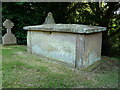
The Hughes tomb in Sheriffhales
An early 19th century chest tomb, dedicated to Robert Hughes who died at the young age of 29. It was Grade II listed https://britishlistedbuildings.co.uk/101053647-hughes-tomb-approximately-19-metres-to-south-of-chancel-of-church-of-st-mary-sheriffhales#.YK6xcqhKhPY & https://historicengland.org.uk/listing/the-list/list-entry/1053647 in 1984.
Image: © Richard Law
Taken: 8 May 2020
0.18 miles
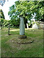
9
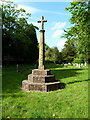
Old cross in St Mary's churchyard, Sheriffhales
Grade II Listed details https://historicengland.org.uk/listing/the-list/list-entry/1367629
Image: © Milestone Society
Taken: Unknown
0.18 miles
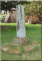
10
Medieval cross base in the churchyard
The base of the cross has origins in the medieval period (no more accurate than that, sorry) and there is evidence that the shaft seen here is an 18th century addition which once held a sundial. It was Grade II listed https://britishlistedbuildings.co.uk/101367629-cross-base-and-sundial-approximately-21-metres-to-north-of-chancel-of-church-of-st-mary-sheriffhales#.YLChBahKhPY & https://historicengland.org.uk/listing/the-list/list-entry/1367629 in 1984.
Image: © Richard Law
Taken: 8 May 2020
0.18 miles