IMAGES TAKEN NEAR TO
Beech Drive, SHIFNAL, TF11 8HZ
Introduction
This page details the photographs taken nearby to Beech Drive, TF11 8HZ by members of the Geograph project.
The Geograph project started in 2005 with the aim of publishing, organising and preserving representative images for every square kilometre of Great Britain, Ireland and the Isle of Man.

There are currently over 7.5m images from over14,400 individuals and you can help contribute to the project by visiting https://www.geograph.org.uk
Image Map (Loading...)


Getting Data...Please wait
Leaflet Map data © OpenStreetMap
Images are licensed for reuse under creativecommons.org/licenses/by-sa/2.0
Notes
- Clicking on the map will re-center to the selected point.
- The higher the marker number, the further away the image location is from the centre of the postcode.
Image Listing (155 Images Found)
Images are licensed for reuse under creativecommons.org/licenses/by-sa/2.0
Image
Details
Distance
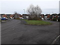
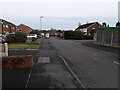
2
Junction of Sycamore Close with Beech Drive
Image: © Richard Law
Taken: 17 Jan 2021
0.05 miles
3
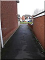
Path between houses on Beech Drive
The path runs between the cul-de-sac of Maple Close and Beech Drive.
Image: © Richard Law
Taken: 17 Jan 2021
0.05 miles
4
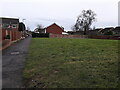
Footpath on a housing estate
A footpath running between Sycamore Close (at the far end) and Laburnum Close (behind the photographer), with a small open play area on the right.
Image: © Richard Law
Taken: 17 Jan 2021
0.05 miles
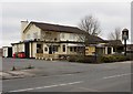
5

The Beehive
At the junction of Curriers Lane and Broadway.
Image: © David Rogers
Taken: 15 May 2009
0.06 miles
6
Junction of Maple Close with Beech Drive
Image: © Richard Law
Taken: 17 Jan 2021
0.06 miles
7
Royal George, Shifnal
What a difference a coat of paint makes! See Image
Image: © Mike White
Taken: 10 Mar 2010
0.08 miles
8
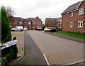
The Willows, Shifnal
Cul-de-sac on the west side of High Street.
Image: © Jaggery
Taken: 16 Nov 2015
0.08 miles
9
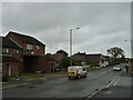
Junction of Wheatfield Drive with Beech Drive
Image: © Richard Law
Taken: 14 Jan 2021
0.08 miles
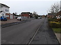
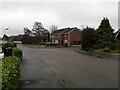
10
Broadway at the junction with Curriers Lane
The houses on the left of the street are sheltered homes for elderly residents, whilst just out of shot on the right are some new builds being erected Image on the site of the former Image
Just visible above the rooftops there's a military C130 'Hercules' transport plane, caught in the shot in the middle of a training flight from RAF Brize Norton. It returned to base at approximately 15:20 in the afternoon, following a grand tour of the northern part of the West Midlands, and then a fair chunk of East Anglia too.
Image: © Richard Law
Taken: 19 Oct 2021
0.09 miles