IMAGES TAKEN NEAR TO
Shay Lane, NEWPORT, TF10 8DL
Introduction
This page details the photographs taken nearby to Shay Lane, TF10 8DL by members of the Geograph project.
The Geograph project started in 2005 with the aim of publishing, organising and preserving representative images for every square kilometre of Great Britain, Ireland and the Isle of Man.

There are currently over 7.5m images from over14,400 individuals and you can help contribute to the project by visiting https://www.geograph.org.uk
Image Map (Loading...)


Getting Data...Please wait
Leaflet Map data © OpenStreetMap
Images are licensed for reuse under creativecommons.org/licenses/by-sa/2.0
Notes
- Clicking on the map will re-center to the selected point.
- The higher the marker number, the further away the image location is from the centre of the postcode.
Image Listing (7 Images Found)
Images are licensed for reuse under creativecommons.org/licenses/by-sa/2.0
Image
Details
Distance
2
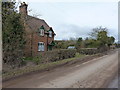
Cottage at Whitley Ford farm
Built in 1901 by 'TFB' according to the stone set high on the front wall.
Image: © Richard Law
Taken: 28 Feb 2015
0.11 miles
3
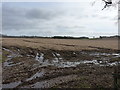
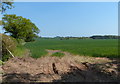
Roman Road to the southeast
The line of the Via Devana, a military road from Chester to Colchester, cuts invisibly across this field. The nearest fort to the south was Pennocrucium near Penkridge, whilst the map suggests there is/was another to the northwest near 'Camp Farm' at Ellerton. That would probably be a reasonable day's march for a troop of armed soldiers of about 13 or 14 miles.
Image: © Richard Law
Taken: 28 Feb 2015
0.12 miles
5
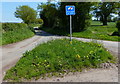
Shay Lane at the junction with Fernhill Road
Image: © Richard Law
Taken: 28 Feb 2015
0.23 miles
7
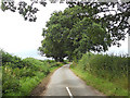
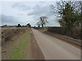
Shay Lane towards Brickhill Pits copse
Shay Lane is the route between Forton and Shebdon.
Image: © Richard Law
Taken: 28 Feb 2015
0.25 miles